V46A Holladay, TN, USA - Earthquake Result Viewer
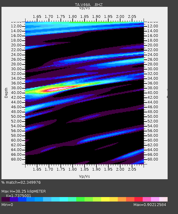
Earthquake location: Near East Coast Of Honshu, Japan
Earthquake latitude/longitude: 38.9/141.8
Earthquake time(UTC): 2012/06/17 (169) 20:32:20 GMT
Earthquake Depth: 36 km
Earthquake Magnitude: 6.0 MB, 5.9 MS, 6.3 MW, 6.4 MW
Earthquake Catalog/Contributor: WHDF/NEIC
Network: TA USArray Transportable Network (new EarthScope stations)
Station: V46A Holladay, TN, USA
Lat/Lon: 35.80 N/88.12 W
Elevation: 162 m
Distance: 92.5 deg
Az: 38.525 deg
Baz: 323.294 deg
Ray Param: 0.041432932
Estimated Moho Depth: 38.25 km
Estimated Crust Vp/Vs: 1.74
Assumed Crust Vp: 6.38 km/s
Estimated Crust Vs: 3.672 km/s
Estimated Crust Poisson's Ratio: 0.25
Radial Match: 82.349976 %
Radial Bump: 400
Transverse Match: 56.033707 %
Transverse Bump: 400
SOD ConfigId: 460165
Insert Time: 2013-02-11 21:34:44.041 +0000
GWidth: 2.5
Max Bumps: 400
Tol: 0.001

Signal To Noise

ChannelStoNSTALTA
TA:V46A: :BHZ:20120617T20:44:56.675022Z4.66487553.4960343E-77.4943785E-8
TA:V46A: :BHN:20120617T20:44:56.675022Z1.74292361.09526944E-76.284093E-8
TA:V46A: :BHE:20120617T20:44:56.675022Z0.946738666.621466E-86.9939745E-8
Arrivals
Ps4.5 SECOND
PpPs16 SECOND
PsPs/PpSs21 SECOND