You are here: Home > Network List > CI - Caltech Regional Seismic Network Stations List
> Station DAN Danby, California, USA > Earthquake Result Viewer
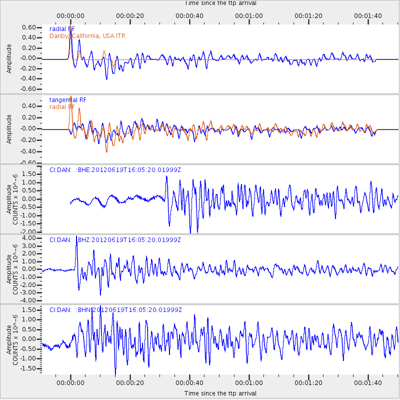
DAN Danby, California, USA - Earthquake Result Viewer
*The percent match for this event was below the threshold and hence no stack was calculated.
| Earthquake location: |
Near Islands, Aleutian Islands |
| Earthquake latitude/longitude: |
53.4/171.6 |
| Earthquake time(UTC): |
2012/06/19 (171) 15:56:32 GMT |
| Earthquake Depth: |
14 km |
| Earthquake Magnitude: |
6.2 MB, 5.7 MS, 6.0 MW, 6.1 MW |
| Earthquake Catalog/Contributor: |
WHDF/NEIC |
|
| Network: |
CI Caltech Regional Seismic Network |
| Station: |
DAN Danby, California, USA |
| Lat/Lon: |
34.64 N/115.38 W |
| Elevation: |
398 m |
|
| Distance: |
53.3 deg |
| Az: |
79.493 deg |
| Baz: |
314.368 deg |
| Ray Param: |
$rayparam |
*The percent match for this event was below the threshold and hence was not used in the summary stack. |
|
| Radial Match: |
74.82769 % |
| Radial Bump: |
400 |
| Transverse Match: |
72.8109 % |
| Transverse Bump: |
400 |
| SOD ConfigId: |
460165 |
| Insert Time: |
2013-02-11 21:48:17.636 +0000 |
| GWidth: |
2.5 |
| Max Bumps: |
400 |
| Tol: |
0.001 |
|
Signal To Noise
| Channel | StoN | STA | LTA |
| CI:DAN: :BHZ:20120619T16:05:20.01999Z | 16.069134 | 1.3971865E-6 | 8.694846E-8 |
| CI:DAN: :BHN:20120619T16:05:20.01999Z | 1.9083873 | 4.4391285E-7 | 2.3261153E-7 |
| CI:DAN: :BHE:20120619T16:05:20.01999Z | 3.8675528 | 6.608137E-7 | 1.7086096E-7 |
| Arrivals |
| Ps | |
| PpPs | |
| PsPs/PpSs | |


