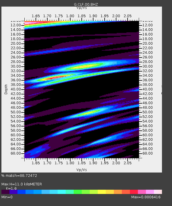
CLF Chambon la Foret observatory, France - Earthquake Result Viewer
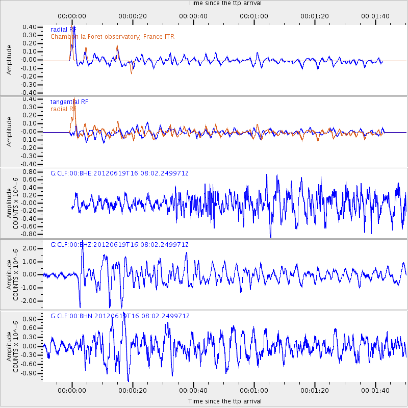
Earthquake location: Near Islands, Aleutian Islands
Earthquake latitude/longitude: 53.4/171.6
Earthquake time(UTC): 2012/06/19 (171) 15:56:32 GMT
Earthquake Depth: 14 km
Earthquake Magnitude: 6.2 MB, 5.7 MS, 6.0 MW, 6.1 MW
Earthquake Catalog/Contributor: WHDF/NEIC
Network: G GEOSCOPE
Station: CLF Chambon la Foret observatory, France
Lat/Lon: 48.03 N/2.26 E
Elevation: 145 m
Distance: 78.6 deg
Az: 352.735 deg
Baz: 6.484 deg
Ray Param: 0.04952727
Estimated Moho Depth: 11.0 km
Estimated Crust Vp/Vs: 1.60
Assumed Crust Vp: 6.12 km/s
Estimated Crust Vs: 3.825 km/s
Estimated Crust Poisson's Ratio: 0.18
Radial Match: 88.72472 %
Radial Bump: 386
Transverse Match: 80.084854 %
Transverse Bump: 400
SOD ConfigId: 460165
Insert Time: 2013-02-11 21:51:19.982 +0000
GWidth: 2.5
Max Bumps: 400
Tol: 0.001

Signal To Noise

ChannelStoNSTALTA
G:CLF:00:BHZ:20120619T16:08:02.249971Z12.4844429.630775E-77.714221E-8
G:CLF:00:BHN:20120619T16:08:02.249971Z1.9816142.2310769E-71.1258888E-7
G:CLF:00:BHE:20120619T16:08:02.249971Z1.41463821.6793803E-71.18714475E-7
Arrivals
Ps1.1 SECOND
PpPs4.5 SECOND
PsPs/PpSs5.6 SECOND