You are here: Home > Network List > TA - USArray Transportable Network (new EarthScope stations) Stations List
> Station G03D McMinnville, OR, USA > Earthquake Result Viewer
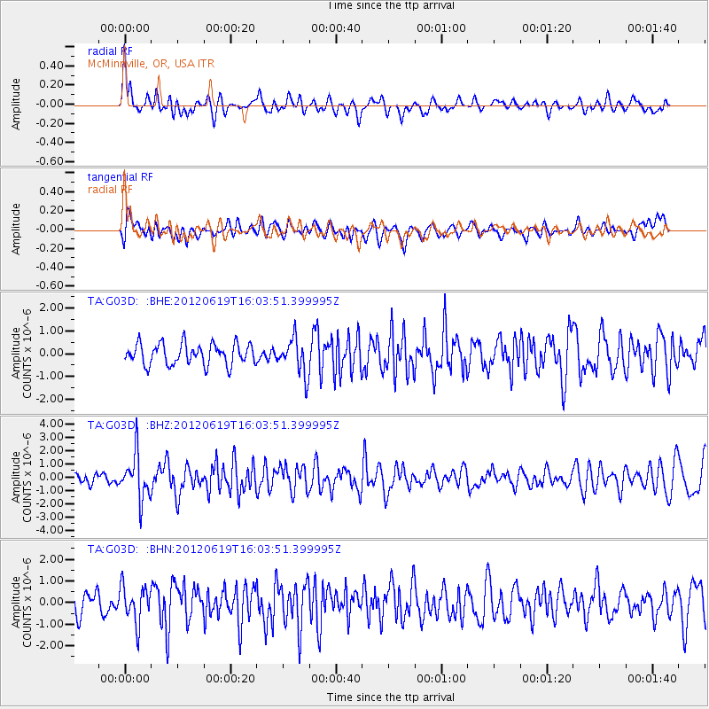
G03D McMinnville, OR, USA - Earthquake Result Viewer
*The percent match for this event was below the threshold and hence no stack was calculated.
| Earthquake location: |
Near Islands, Aleutian Islands |
| Earthquake latitude/longitude: |
53.4/171.6 |
| Earthquake time(UTC): |
2012/06/19 (171) 15:56:32 GMT |
| Earthquake Depth: |
14 km |
| Earthquake Magnitude: |
6.2 MB, 5.7 MS, 6.0 MW, 6.1 MW |
| Earthquake Catalog/Contributor: |
WHDF/NEIC |
|
| Network: |
TA USArray Transportable Network (new EarthScope stations) |
| Station: |
G03D McMinnville, OR, USA |
| Lat/Lon: |
45.21 N/123.26 W |
| Elevation: |
222 m |
|
| Distance: |
41.9 deg |
| Az: |
73.826 deg |
| Baz: |
305.46 deg |
| Ray Param: |
$rayparam |
*The percent match for this event was below the threshold and hence was not used in the summary stack. |
|
| Radial Match: |
61.496727 % |
| Radial Bump: |
400 |
| Transverse Match: |
42.687256 % |
| Transverse Bump: |
400 |
| SOD ConfigId: |
460165 |
| Insert Time: |
2013-02-11 22:02:32.040 +0000 |
| GWidth: |
2.5 |
| Max Bumps: |
400 |
| Tol: |
0.001 |
|
Signal To Noise
| Channel | StoN | STA | LTA |
| TA:G03D: :BHZ:20120619T16:03:51.399995Z | 5.2008796 | 1.6916736E-6 | 3.2526683E-7 |
| TA:G03D: :BHN:20120619T16:03:51.399995Z | 1.7611955 | 8.5846597E-7 | 4.874336E-7 |
| TA:G03D: :BHE:20120619T16:03:51.399995Z | 1.7390003 | 8.0105247E-7 | 4.6063965E-7 |
| Arrivals |
| Ps | |
| PpPs | |
| PsPs/PpSs | |


