You are here: Home > Network List > TA - USArray Transportable Network (new EarthScope stations) Stations List
> Station C31A Landman Farms, Northwood, ND, USA > Earthquake Result Viewer
C31A Landman Farms, Northwood, ND, USA - Earthquake Result Viewer
| Earthquake location: |
Near Islands, Aleutian Islands |
| Earthquake latitude/longitude: |
53.4/171.6 |
| Earthquake time(UTC): |
2012/06/19 (171) 15:56:32 GMT |
| Earthquake Depth: |
14 km |
| Earthquake Magnitude: |
6.2 MB, 5.7 MS, 6.0 MW, 6.1 MW |
| Earthquake Catalog/Contributor: |
WHDF/NEIC |
|
| Network: |
TA USArray Transportable Network (new EarthScope stations) |
| Station: |
C31A Landman Farms, Northwood, ND, USA |
| Lat/Lon: |
47.79 N/97.73 W |
| Elevation: |
384 m |
|
| Distance: |
54.1 deg |
| Az: |
56.351 deg |
| Baz: |
312.26 deg |
| Ray Param: |
0.06565483 |
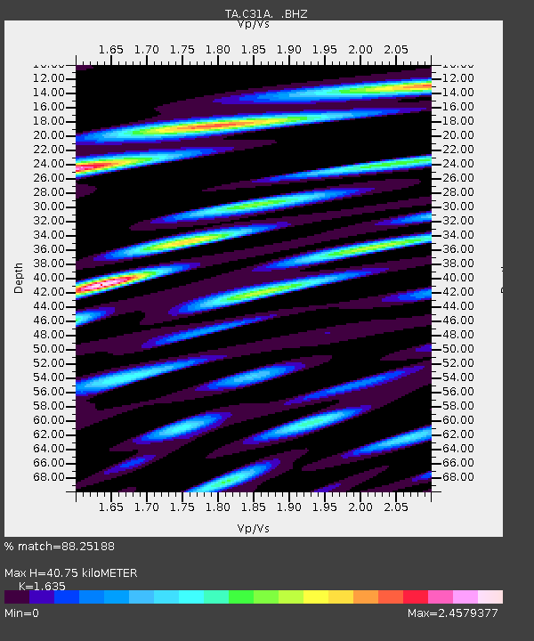
| Estimated Moho Depth: |
40.75 km |
| Estimated Crust Vp/Vs: |
1.63 |
| Assumed Crust Vp: |
6.498 km/s |
| Estimated Crust Vs: |
3.974 km/s |
| Estimated Crust Poisson's Ratio: |
0.20 |
|
| Radial Match: |
88.25188 % |
| Radial Bump: |
400 |
| Transverse Match: |
72.67047 % |
| Transverse Bump: |
400 |
| SOD ConfigId: |
460165 |
| Insert Time: |
2013-02-11 22:04:59.466 +0000 |
| GWidth: |
2.5 |
| Max Bumps: |
400 |
| Tol: |
0.001 |
|

Signal To Noise
| Channel | StoN | STA | LTA |
| TA:C31A: :BHZ:20120619T16:05:25.67502Z | 14.976101 | 1.0428233E-6 | 6.96325E-8 |
| TA:C31A: :BHN:20120619T16:05:25.67502Z | 6.411534 | 5.199517E-7 | 8.109631E-8 |
| TA:C31A: :BHE:20120619T16:05:25.67502Z | 8.575461 | 7.76616E-7 | 9.0562594E-8 |
| Arrivals |
| Ps | 4.2 SECOND |
| PpPs | 16 SECOND |
| PsPs/PpSs | 20 SECOND |


