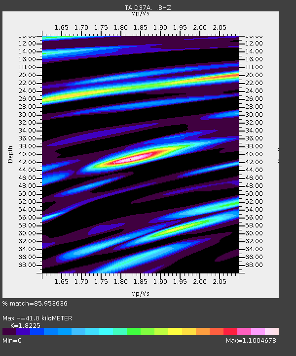
D37A Cotton, MN, USA - Earthquake Result Viewer

Earthquake location: Near Islands, Aleutian Islands
Earthquake latitude/longitude: 53.4/171.6
Earthquake time(UTC): 2012/06/19 (171) 15:56:32 GMT
Earthquake Depth: 14 km
Earthquake Magnitude: 6.2 MB, 5.7 MS, 6.0 MW, 6.1 MW
Earthquake Catalog/Contributor: WHDF/NEIC
Network: TA USArray Transportable Network (new EarthScope stations)
Station: D37A Cotton, MN, USA
Lat/Lon: 47.16 N/92.43 W
Elevation: 413 m
Distance: 57.1 deg
Az: 53.905 deg
Baz: 314.779 deg
Ray Param: 0.06367232
Estimated Moho Depth: 41.0 km
Estimated Crust Vp/Vs: 1.82
Assumed Crust Vp: 6.571 km/s
Estimated Crust Vs: 3.605 km/s
Estimated Crust Poisson's Ratio: 0.28
Radial Match: 85.953636 %
Radial Bump: 400
Transverse Match: 80.2476 %
Transverse Bump: 400
SOD ConfigId: 460165
Insert Time: 2013-02-11 22:05:55.186 +0000
GWidth: 2.5
Max Bumps: 400
Tol: 0.001

Signal To Noise

ChannelStoNSTALTA
TA:D37A: :BHZ:20120619T16:05:47.55002Z14.0736021.0454551E-67.428483E-8
TA:D37A: :BHN:20120619T16:05:47.55002Z4.42425543.38764E-77.656973E-8
TA:D37A: :BHE:20120619T16:05:47.55002Z3.61610084.0086604E-71.1085588E-7
Arrivals
Ps5.4 SECOND
PpPs17 SECOND
PsPs/PpSs22 SECOND