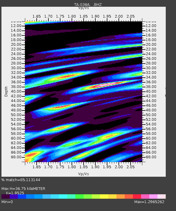
G36A St. Michael, MN, USA - Earthquake Result Viewer

Earthquake location: Near Islands, Aleutian Islands
Earthquake latitude/longitude: 53.4/171.6
Earthquake time(UTC): 2012/06/19 (171) 15:56:32 GMT
Earthquake Depth: 14 km
Earthquake Magnitude: 6.2 MB, 5.7 MS, 6.0 MW, 6.1 MW
Earthquake Catalog/Contributor: WHDF/NEIC
Network: TA USArray Transportable Network (new EarthScope stations)
Station: G36A St. Michael, MN, USA
Lat/Lon: 45.23 N/93.75 W
Elevation: 293 m
Distance: 57.8 deg
Az: 56.291 deg
Baz: 315.108 deg
Ray Param: 0.06322017
Estimated Moho Depth: 36.75 km
Estimated Crust Vp/Vs: 1.95
Assumed Crust Vp: 6.571 km/s
Estimated Crust Vs: 3.365 km/s
Estimated Crust Poisson's Ratio: 0.32
Radial Match: 85.113144 %
Radial Bump: 400
Transverse Match: 68.69713 %
Transverse Bump: 400
SOD ConfigId: 460165
Insert Time: 2013-02-11 22:06:32.539 +0000
GWidth: 2.5
Max Bumps: 400
Tol: 0.001

Signal To Noise

ChannelStoNSTALTA
TA:G36A: :BHZ:20120619T16:05:52.499971Z11.6084281.4119668E-61.2163291E-7
TA:G36A: :BHN:20120619T16:05:52.499971Z3.66826926.014337E-71.6395572E-7
TA:G36A: :BHE:20120619T16:05:52.499971Z2.26728925.8077694E-72.5615478E-7
Arrivals
Ps5.6 SECOND
PpPs16 SECOND
PsPs/PpSs21 SECOND