You are here: Home > Network List > TA - USArray Transportable Network (new EarthScope stations) Stations List
> Station H35A Sunnyside Ranch, Fairfax, MN, USA > Earthquake Result Viewer
H35A Sunnyside Ranch, Fairfax, MN, USA - Earthquake Result Viewer
| Earthquake location: |
Near Islands, Aleutian Islands |
| Earthquake latitude/longitude: |
53.4/171.6 |
| Earthquake time(UTC): |
2012/06/19 (171) 15:56:32 GMT |
| Earthquake Depth: |
14 km |
| Earthquake Magnitude: |
6.2 MB, 5.7 MS, 6.0 MW, 6.1 MW |
| Earthquake Catalog/Contributor: |
WHDF/NEIC |
|
| Network: |
TA USArray Transportable Network (new EarthScope stations) |
| Station: |
H35A Sunnyside Ranch, Fairfax, MN, USA |
| Lat/Lon: |
44.70 N/94.83 W |
| Elevation: |
345 m |
|
| Distance: |
57.7 deg |
| Az: |
57.38 deg |
| Baz: |
314.928 deg |
| Ray Param: |
0.0633247 |
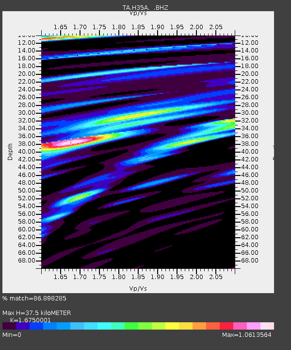
| Estimated Moho Depth: |
37.5 km |
| Estimated Crust Vp/Vs: |
1.68 |
| Assumed Crust Vp: |
6.571 km/s |
| Estimated Crust Vs: |
3.923 km/s |
| Estimated Crust Poisson's Ratio: |
0.22 |
|
| Radial Match: |
86.898285 % |
| Radial Bump: |
400 |
| Transverse Match: |
73.825485 % |
| Transverse Bump: |
400 |
| SOD ConfigId: |
460165 |
| Insert Time: |
2013-02-11 22:07:14.385 +0000 |
| GWidth: |
2.5 |
| Max Bumps: |
400 |
| Tol: |
0.001 |
|
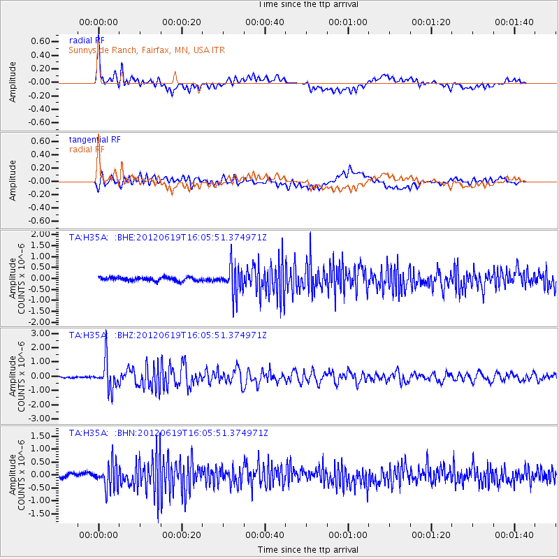
Signal To Noise
| Channel | StoN | STA | LTA |
| TA:H35A: :BHZ:20120619T16:05:51.374971Z | 22.720303 | 1.0262289E-6 | 4.516792E-8 |
| TA:H35A: :BHN:20120619T16:05:51.374971Z | 4.733197 | 4.916874E-7 | 1.0388061E-7 |
| TA:H35A: :BHE:20120619T16:05:51.374971Z | 8.288732 | 6.664818E-7 | 8.040817E-8 |
| Arrivals |
| Ps | 4.1 SECOND |
| PpPs | 14 SECOND |
| PsPs/PpSs | 19 SECOND |


