You are here: Home > Network List > TA - USArray Transportable Network (new EarthScope stations) Stations List
> Station H36A Jessenland, Henderson, MN, USA > Earthquake Result Viewer
H36A Jessenland, Henderson, MN, USA - Earthquake Result Viewer
| Earthquake location: |
Near Islands, Aleutian Islands |
| Earthquake latitude/longitude: |
53.4/171.6 |
| Earthquake time(UTC): |
2012/06/19 (171) 15:56:32 GMT |
| Earthquake Depth: |
14 km |
| Earthquake Magnitude: |
6.2 MB, 5.7 MS, 6.0 MW, 6.1 MW |
| Earthquake Catalog/Contributor: |
WHDF/NEIC |
|
| Network: |
TA USArray Transportable Network (new EarthScope stations) |
| Station: |
H36A Jessenland, Henderson, MN, USA |
| Lat/Lon: |
44.58 N/93.93 W |
| Elevation: |
311 m |
|
| Distance: |
58.2 deg |
| Az: |
56.941 deg |
| Baz: |
315.327 deg |
| Ray Param: |
0.062974095 |
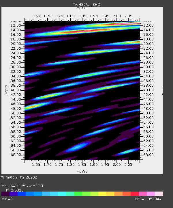
| Estimated Moho Depth: |
10.75 km |
| Estimated Crust Vp/Vs: |
2.08 |
| Assumed Crust Vp: |
6.571 km/s |
| Estimated Crust Vs: |
3.155 km/s |
| Estimated Crust Poisson's Ratio: |
0.35 |
|
| Radial Match: |
92.26202 % |
| Radial Bump: |
400 |
| Transverse Match: |
85.61053 % |
| Transverse Bump: |
400 |
| SOD ConfigId: |
460165 |
| Insert Time: |
2013-02-11 22:07:26.524 +0000 |
| GWidth: |
2.5 |
| Max Bumps: |
400 |
| Tol: |
0.001 |
|

Signal To Noise
| Channel | StoN | STA | LTA |
| TA:H36A: :BHZ:20120619T16:05:55.149995Z | 16.557257 | 3.0554804E-6 | 1.8454026E-7 |
| TA:H36A: :BHN:20120619T16:05:55.149995Z | 2.9836228 | 1.1510801E-6 | 3.857995E-7 |
| TA:H36A: :BHE:20120619T16:05:55.149995Z | 2.5834632 | 1.1868087E-6 | 4.593867E-7 |
| Arrivals |
| Ps | 1.8 SECOND |
| PpPs | 4.8 SECOND |
| PsPs/PpSs | 6.7 SECOND |


