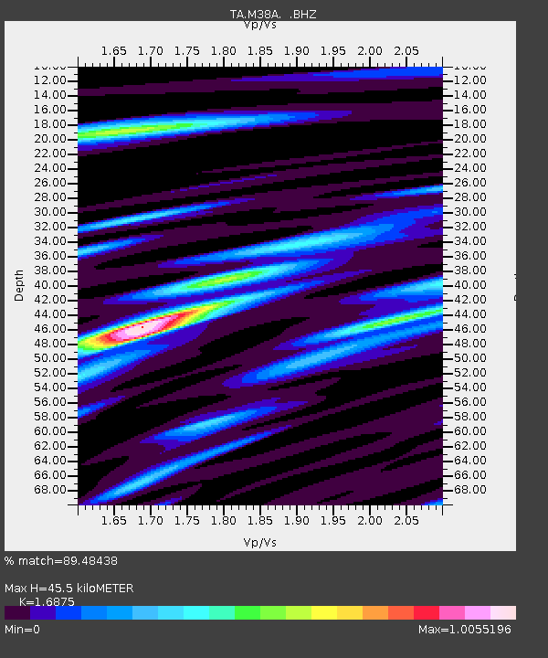
M38A Pleasantville, IA, USA - Earthquake Result Viewer

Earthquake location: Near Islands, Aleutian Islands
Earthquake latitude/longitude: 53.4/171.6
Earthquake time(UTC): 2012/06/19 (171) 15:56:32 GMT
Earthquake Depth: 14 km
Earthquake Magnitude: 6.2 MB, 5.7 MS, 6.0 MW, 6.1 MW
Earthquake Catalog/Contributor: WHDF/NEIC
Network: TA USArray Transportable Network (new EarthScope stations)
Station: M38A Pleasantville, IA, USA
Lat/Lon: 41.42 N/93.20 W
Elevation: 258 m
Distance: 60.9 deg
Az: 59.033 deg
Baz: 316.885 deg
Ray Param: 0.06123543
Estimated Moho Depth: 45.5 km
Estimated Crust Vp/Vs: 1.69
Assumed Crust Vp: 6.498 km/s
Estimated Crust Vs: 3.85 km/s
Estimated Crust Poisson's Ratio: 0.23
Radial Match: 89.48438 %
Radial Bump: 400
Transverse Match: 63.27905 %
Transverse Bump: 400
SOD ConfigId: 460165
Insert Time: 2013-02-11 22:09:45.947 +0000
GWidth: 2.5
Max Bumps: 400
Tol: 0.001

Signal To Noise

ChannelStoNSTALTA
TA:M38A: :BHZ:20120619T16:06:13.399995Z11.0234549.689362E-78.7897696E-8
TA:M38A: :BHN:20120619T16:06:13.399995Z2.82382824.322889E-71.5308612E-7
TA:M38A: :BHE:20120619T16:06:13.399995Z2.51595573.6527987E-71.4518534E-7
Arrivals
Ps5.1 SECOND
PpPs18 SECOND
PsPs/PpSs23 SECOND