You are here: Home > Network List > TA - USArray Transportable Network (new EarthScope stations) Stations List
> Station V60A Jim Taylor Road, Stokes, NC, USA > Earthquake Result Viewer
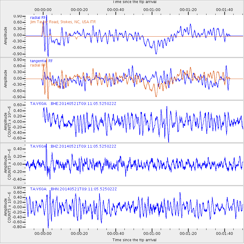
V60A Jim Taylor Road, Stokes, NC, USA - Earthquake Result Viewer
*The percent match for this event was below the threshold and hence no stack was calculated.
| Earthquake location: |
Near Coast Of Central Chile |
| Earthquake latitude/longitude: |
-30.4/-71.4 |
| Earthquake time(UTC): |
2014/05/21 (141) 09:00:53 GMT |
| Earthquake Depth: |
41 km |
| Earthquake Magnitude: |
5.1 MW |
| Earthquake Catalog/Contributor: |
ISC/ISC |
|
| Network: |
TA USArray Transportable Network (new EarthScope stations) |
| Station: |
V60A Jim Taylor Road, Stokes, NC, USA |
| Lat/Lon: |
35.76 N/77.26 W |
| Elevation: |
8.0 m |
|
| Distance: |
66.1 deg |
| Az: |
354.752 deg |
| Baz: |
174.427 deg |
| Ray Param: |
$rayparam |
*The percent match for this event was below the threshold and hence was not used in the summary stack. |
|
| Radial Match: |
66.03727 % |
| Radial Bump: |
400 |
| Transverse Match: |
49.612606 % |
| Transverse Bump: |
400 |
| SOD ConfigId: |
3390531 |
| Insert Time: |
2019-04-11 23:37:36.030 +0000 |
| GWidth: |
2.5 |
| Max Bumps: |
400 |
| Tol: |
0.001 |
|
Signal To Noise
| Channel | StoN | STA | LTA |
| TA:V60A: :BHZ:20140521T09:11:05.525022Z | 2.1096902 | 1.8664774E-7 | 8.8471644E-8 |
| TA:V60A: :BHN:20140521T09:11:05.525022Z | 1.670714 | 3.7557072E-7 | 2.2479654E-7 |
| TA:V60A: :BHE:20140521T09:11:05.525022Z | 0.7585487 | 1.5581323E-7 | 2.0540965E-7 |
| Arrivals |
| Ps | |
| PpPs | |
| PsPs/PpSs | |


