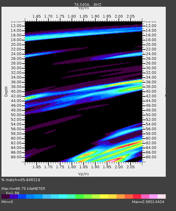
S40A Lebanon, MO, USA - Earthquake Result Viewer

Earthquake location: Near Islands, Aleutian Islands
Earthquake latitude/longitude: 53.4/171.6
Earthquake time(UTC): 2012/06/19 (171) 15:56:32 GMT
Earthquake Depth: 14 km
Earthquake Magnitude: 6.2 MB, 5.7 MS, 6.0 MW, 6.1 MW
Earthquake Catalog/Contributor: WHDF/NEIC
Network: TA USArray Transportable Network (new EarthScope stations)
Station: S40A Lebanon, MO, USA
Lat/Lon: 37.60 N/92.50 W
Elevation: 336 m
Distance: 64.1 deg
Az: 61.48 deg
Baz: 318.458 deg
Ray Param: 0.059162654
Estimated Moho Depth: 69.75 km
Estimated Crust Vp/Vs: 1.96
Assumed Crust Vp: 6.53 km/s
Estimated Crust Vs: 3.332 km/s
Estimated Crust Poisson's Ratio: 0.32
Radial Match: 85.649216 %
Radial Bump: 400
Transverse Match: 66.787704 %
Transverse Bump: 400
SOD ConfigId: 460165
Insert Time: 2013-02-11 22:11:25.196 +0000
GWidth: 2.5
Max Bumps: 400
Tol: 0.001

Signal To Noise

ChannelStoNSTALTA
TA:S40A: :BHZ:20120619T16:06:34.624971Z16.621896.9897266E-74.205134E-8
TA:S40A: :BHN:20120619T16:06:34.624971Z5.4425922.751741E-75.0559382E-8
TA:S40A: :BHE:20120619T16:06:34.624971Z5.57219932.968716E-75.3277276E-8
Arrivals
Ps11 SECOND
PpPs30 SECOND
PsPs/PpSs41 SECOND