You are here: Home > Network List > TA - USArray Transportable Network (new EarthScope stations) Stations List
> Station S39A Bolivar, MO, USA > Earthquake Result Viewer
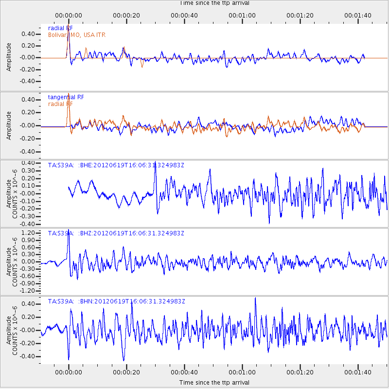
S39A Bolivar, MO, USA - Earthquake Result Viewer
*The percent match for this event was below the threshold and hence no stack was calculated.
| Earthquake location: |
Near Islands, Aleutian Islands |
| Earthquake latitude/longitude: |
53.4/171.6 |
| Earthquake time(UTC): |
2012/06/19 (171) 15:56:32 GMT |
| Earthquake Depth: |
14 km |
| Earthquake Magnitude: |
6.2 MB, 5.7 MS, 6.0 MW, 6.1 MW |
| Earthquake Catalog/Contributor: |
WHDF/NEIC |
|
| Network: |
TA USArray Transportable Network (new EarthScope stations) |
| Station: |
S39A Bolivar, MO, USA |
| Lat/Lon: |
37.69 N/93.32 W |
| Elevation: |
331 m |
|
| Distance: |
63.6 deg |
| Az: |
61.954 deg |
| Baz: |
318.168 deg |
| Ray Param: |
$rayparam |
*The percent match for this event was below the threshold and hence was not used in the summary stack. |
|
| Radial Match: |
75.442696 % |
| Radial Bump: |
400 |
| Transverse Match: |
60.151485 % |
| Transverse Bump: |
400 |
| SOD ConfigId: |
460165 |
| Insert Time: |
2013-02-11 22:11:33.945 +0000 |
| GWidth: |
2.5 |
| Max Bumps: |
400 |
| Tol: |
0.001 |
|
Signal To Noise
| Channel | StoN | STA | LTA |
| TA:S39A: :BHZ:20120619T16:06:31.324983Z | 9.558533 | 4.967172E-7 | 5.1965838E-8 |
| TA:S39A: :BHN:20120619T16:06:31.324983Z | 3.8680656 | 1.8522732E-7 | 4.7886296E-8 |
| TA:S39A: :BHE:20120619T16:06:31.324983Z | 1.8454415 | 1.5600149E-7 | 8.4533426E-8 |
| Arrivals |
| Ps | |
| PpPs | |
| PsPs/PpSs | |


