You are here: Home > Network List > TA - USArray Transportable Network (new EarthScope stations) Stations List
> Station 241A Mo Tay, Goldonna, LA, USA > Earthquake Result Viewer
241A Mo Tay, Goldonna, LA, USA - Earthquake Result Viewer

| Earthquake location: |
Near Islands, Aleutian Islands |
| Earthquake latitude/longitude: |
53.4/171.6 |
| Earthquake time(UTC): |
2012/06/19 (171) 15:56:32 GMT |
| Earthquake Depth: |
14 km |
| Earthquake Magnitude: |
6.2 MB, 5.7 MS, 6.0 MW, 6.1 MW |
| Earthquake Catalog/Contributor: |
WHDF/NEIC |
|
| Network: |
TA USArray Transportable Network (new EarthScope stations) |
| Station: |
241A Mo Tay, Goldonna, LA, USA |
| Lat/Lon: |
32.02 N/92.92 W |
| Elevation: |
59 m |
|
| Distance: |
68.0 deg |
| Az: |
65.741 deg |
| Baz: |
319.952 deg |
| Ray Param: |
0.05655288 |
| Estimated Moho Depth: |
13.75 km |
| Estimated Crust Vp/Vs: |
1.60 |
| Assumed Crust Vp: |
6.245 km/s |
| Estimated Crust Vs: |
3.903 km/s |
| Estimated Crust Poisson's Ratio: |
0.18 |
|
| Radial Match: |
83.788864 % |
| Radial Bump: |
400 |
| Transverse Match: |
68.61075 % |
| Transverse Bump: |
400 |
| SOD ConfigId: |
460165 |
| Insert Time: |
2013-02-11 22:12:45.996 +0000 |
| GWidth: |
2.5 |
| Max Bumps: |
400 |
| Tol: |
0.001 |
|
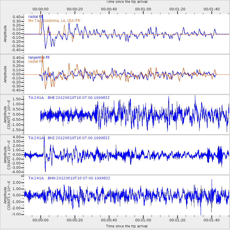
Signal To Noise
| Channel | StoN | STA | LTA |
| TA:241A: :BHZ:20120619T16:07:00.199983Z | 4.690112 | 1.4312177E-6 | 3.051564E-7 |
| TA:241A: :BHN:20120619T16:07:00.199983Z | 1.2353808 | 4.9640204E-7 | 4.018211E-7 |
| TA:241A: :BHE:20120619T16:07:00.199983Z | 1.8684851 | 5.210471E-7 | 2.7886074E-7 |
| Arrivals |
| Ps | 1.4 SECOND |
| PpPs | 5.5 SECOND |
| PsPs/PpSs | 6.9 SECOND |


