You are here: Home > Network List > TA - USArray Transportable Network (new EarthScope stations) Stations List
> Station 143A Socs Landing, Pioneer, LA, USA > Earthquake Result Viewer
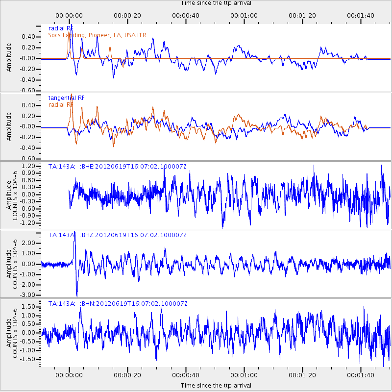
143A Socs Landing, Pioneer, LA, USA - Earthquake Result Viewer
*The percent match for this event was below the threshold and hence no stack was calculated.
| Earthquake location: |
Near Islands, Aleutian Islands |
| Earthquake latitude/longitude: |
53.4/171.6 |
| Earthquake time(UTC): |
2012/06/19 (171) 15:56:32 GMT |
| Earthquake Depth: |
14 km |
| Earthquake Magnitude: |
6.2 MB, 5.7 MS, 6.0 MW, 6.1 MW |
| Earthquake Catalog/Contributor: |
WHDF/NEIC |
|
| Network: |
TA USArray Transportable Network (new EarthScope stations) |
| Station: |
143A Socs Landing, Pioneer, LA, USA |
| Lat/Lon: |
32.70 N/91.40 W |
| Elevation: |
30 m |
|
| Distance: |
68.3 deg |
| Az: |
64.213 deg |
| Baz: |
320.191 deg |
| Ray Param: |
$rayparam |
*The percent match for this event was below the threshold and hence was not used in the summary stack. |
|
| Radial Match: |
73.58393 % |
| Radial Bump: |
400 |
| Transverse Match: |
33.279797 % |
| Transverse Bump: |
400 |
| SOD ConfigId: |
460165 |
| Insert Time: |
2013-02-11 22:13:10.817 +0000 |
| GWidth: |
2.5 |
| Max Bumps: |
400 |
| Tol: |
0.001 |
|
Signal To Noise
| Channel | StoN | STA | LTA |
| TA:143A: :BHZ:20120619T16:07:02.100007Z | 8.992386 | 1.2632863E-6 | 1.4048399E-7 |
| TA:143A: :BHN:20120619T16:07:02.100007Z | 1.7903286 | 5.406208E-7 | 3.0196736E-7 |
| TA:143A: :BHE:20120619T16:07:02.100007Z | 1.6235852 | 4.013995E-7 | 2.472303E-7 |
| Arrivals |
| Ps | |
| PpPs | |
| PsPs/PpSs | |


