You are here: Home > Network List > TA - USArray Transportable Network (new EarthScope stations) Stations List
> Station 146A Union, MS, USA > Earthquake Result Viewer
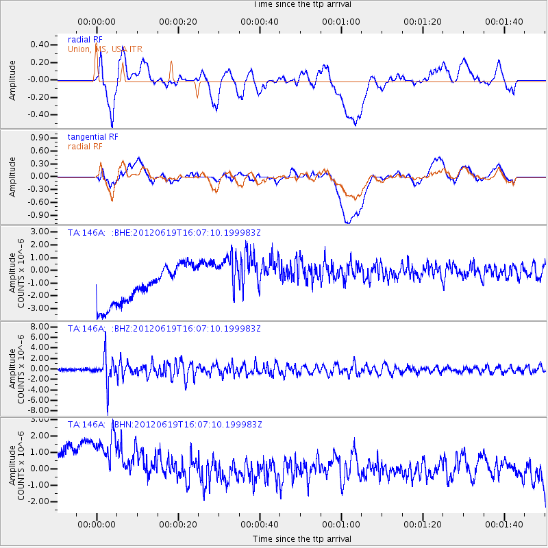
146A Union, MS, USA - Earthquake Result Viewer
*The percent match for this event was below the threshold and hence no stack was calculated.
| Earthquake location: |
Near Islands, Aleutian Islands |
| Earthquake latitude/longitude: |
53.4/171.6 |
| Earthquake time(UTC): |
2012/06/19 (171) 15:56:32 GMT |
| Earthquake Depth: |
14 km |
| Earthquake Magnitude: |
6.2 MB, 5.7 MS, 6.0 MW, 6.1 MW |
| Earthquake Catalog/Contributor: |
WHDF/NEIC |
|
| Network: |
TA USArray Transportable Network (new EarthScope stations) |
| Station: |
146A Union, MS, USA |
| Lat/Lon: |
32.64 N/89.06 W |
| Elevation: |
164 m |
|
| Distance: |
69.7 deg |
| Az: |
62.621 deg |
| Baz: |
320.882 deg |
| Ray Param: |
$rayparam |
*The percent match for this event was below the threshold and hence was not used in the summary stack. |
|
| Radial Match: |
19.443121 % |
| Radial Bump: |
400 |
| Transverse Match: |
8.208262 % |
| Transverse Bump: |
400 |
| SOD ConfigId: |
460165 |
| Insert Time: |
2013-02-11 22:15:01.325 +0000 |
| GWidth: |
2.5 |
| Max Bumps: |
400 |
| Tol: |
0.001 |
|
Signal To Noise
| Channel | StoN | STA | LTA |
| TA:146A: :BHZ:20120619T16:07:10.199983Z | 9.540468 | 2.5834815E-6 | 2.707919E-7 |
| TA:146A: :BHN:20120619T16:07:10.199983Z | 1.4489999 | 4.1930207E-6 | 2.8937343E-6 |
| TA:146A: :BHE:20120619T16:07:10.199983Z | 1.3642241 | 1.9173424E-6 | 1.4054453E-6 |
| Arrivals |
| Ps | |
| PpPs | |
| PsPs/PpSs | |


