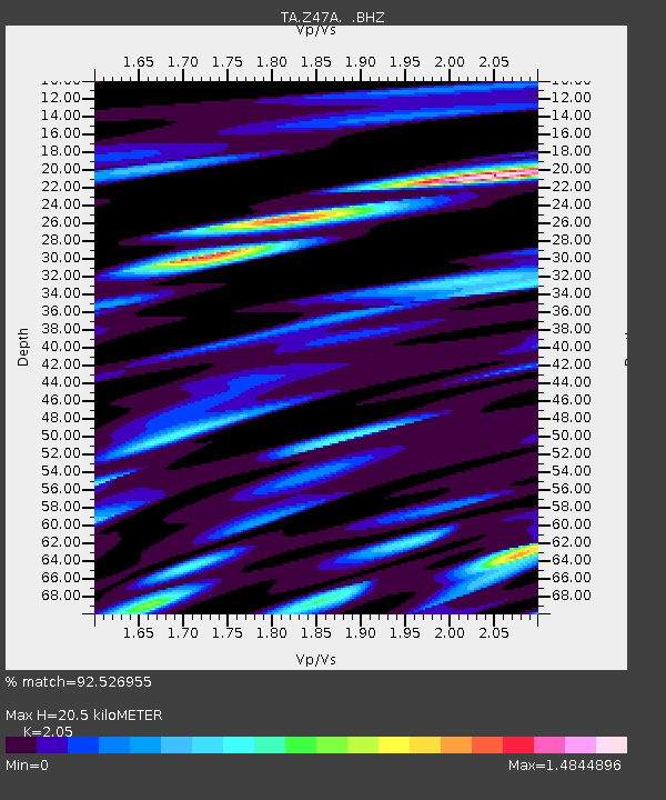
Z47A Carrollton, AL, USA - Earthquake Result Viewer
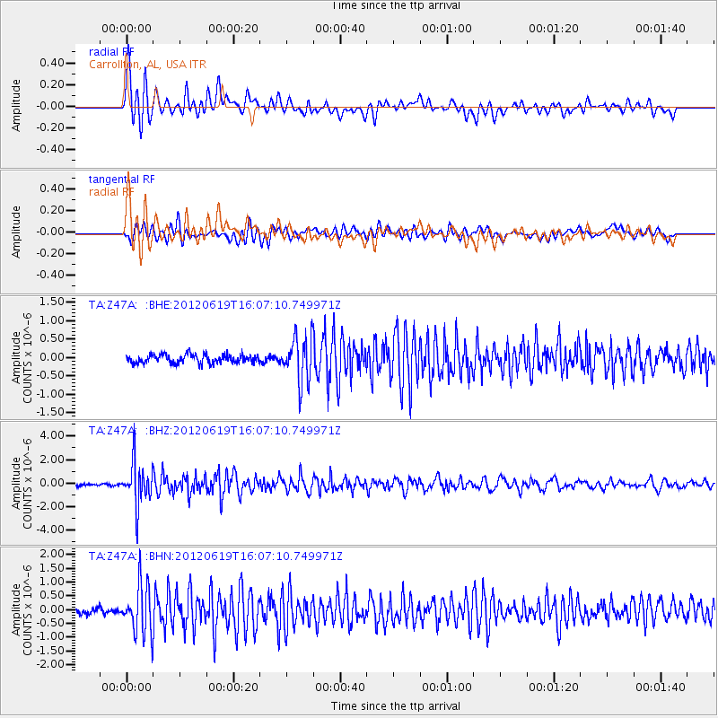
Earthquake location: Near Islands, Aleutian Islands
Earthquake latitude/longitude: 53.4/171.6
Earthquake time(UTC): 2012/06/19 (171) 15:56:32 GMT
Earthquake Depth: 14 km
Earthquake Magnitude: 6.2 MB, 5.7 MS, 6.0 MW, 6.1 MW
Earthquake Catalog/Contributor: WHDF/NEIC
Network: TA USArray Transportable Network (new EarthScope stations)
Station: Z47A Carrollton, AL, USA
Lat/Lon: 33.20 N/88.07 W
Elevation: 65 m
Distance: 69.7 deg
Az: 61.557 deg
Baz: 321.046 deg
Ray Param: 0.055435475
Estimated Moho Depth: 20.5 km
Estimated Crust Vp/Vs: 2.05
Assumed Crust Vp: 6.201 km/s
Estimated Crust Vs: 3.025 km/s
Estimated Crust Poisson's Ratio: 0.34
Radial Match: 92.526955 %
Radial Bump: 400
Transverse Match: 83.76473 %
Transverse Bump: 400
SOD ConfigId: 460165
Insert Time: 2013-02-11 22:16:25.595 +0000
GWidth: 2.5
Max Bumps: 400
Tol: 0.001

Signal To Noise

ChannelStoNSTALTA
TA:Z47A: :BHZ:20120619T16:07:10.749971Z17.8397371.8097214E-61.0144328E-7
TA:Z47A: :BHN:20120619T16:07:10.749971Z9.8681798.938826E-79.0582326E-8
TA:Z47A: :BHE:20120619T16:07:10.749971Z5.2463096.131142E-71.1686582E-7
Arrivals
Ps3.6 SECOND
PpPs9.8 SECOND
PsPs/PpSs13 SECOND