You are here: Home > Network List > TA - USArray Transportable Network (new EarthScope stations) Stations List
> Station Z42A Norrel Spur, Hamburg, AR, USA > Earthquake Result Viewer
Z42A Norrel Spur, Hamburg, AR, USA - Earthquake Result Viewer

| Earthquake location: |
Near Islands, Aleutian Islands |
| Earthquake latitude/longitude: |
53.4/171.6 |
| Earthquake time(UTC): |
2012/06/19 (171) 15:56:32 GMT |
| Earthquake Depth: |
14 km |
| Earthquake Magnitude: |
6.2 MB, 5.7 MS, 6.0 MW, 6.1 MW |
| Earthquake Catalog/Contributor: |
WHDF/NEIC |
|
| Network: |
TA USArray Transportable Network (new EarthScope stations) |
| Station: |
Z42A Norrel Spur, Hamburg, AR, USA |
| Lat/Lon: |
33.27 N/91.95 W |
| Elevation: |
39 m |
|
| Distance: |
67.6 deg |
| Az: |
64.196 deg |
| Baz: |
319.89 deg |
| Ray Param: |
0.05683118 |
| Estimated Moho Depth: |
56.0 km |
| Estimated Crust Vp/Vs: |
2.06 |
| Assumed Crust Vp: |
6.201 km/s |
| Estimated Crust Vs: |
3.014 km/s |
| Estimated Crust Poisson's Ratio: |
0.35 |
|
| Radial Match: |
84.064026 % |
| Radial Bump: |
400 |
| Transverse Match: |
71.728645 % |
| Transverse Bump: |
400 |
| SOD ConfigId: |
460165 |
| Insert Time: |
2013-02-11 22:16:50.507 +0000 |
| GWidth: |
2.5 |
| Max Bumps: |
400 |
| Tol: |
0.001 |
|
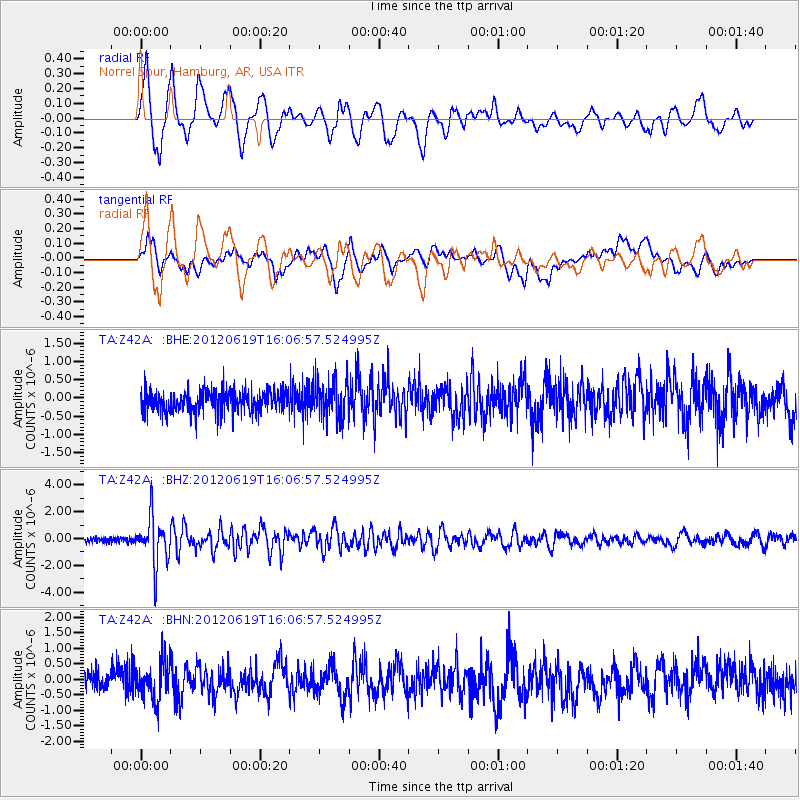
Signal To Noise
| Channel | StoN | STA | LTA |
| TA:Z42A: :BHZ:20120619T16:06:57.524995Z | 10.484166 | 1.7365654E-6 | 1.6563696E-7 |
| TA:Z42A: :BHN:20120619T16:06:57.524995Z | 1.9854223 | 5.9936883E-7 | 3.0188482E-7 |
| TA:Z42A: :BHE:20120619T16:06:57.524995Z | 1.6907464 | 4.8755146E-7 | 2.8836462E-7 |
| Arrivals |
| Ps | 9.9 SECOND |
| PpPs | 27 SECOND |
| PsPs/PpSs | 37 SECOND |


