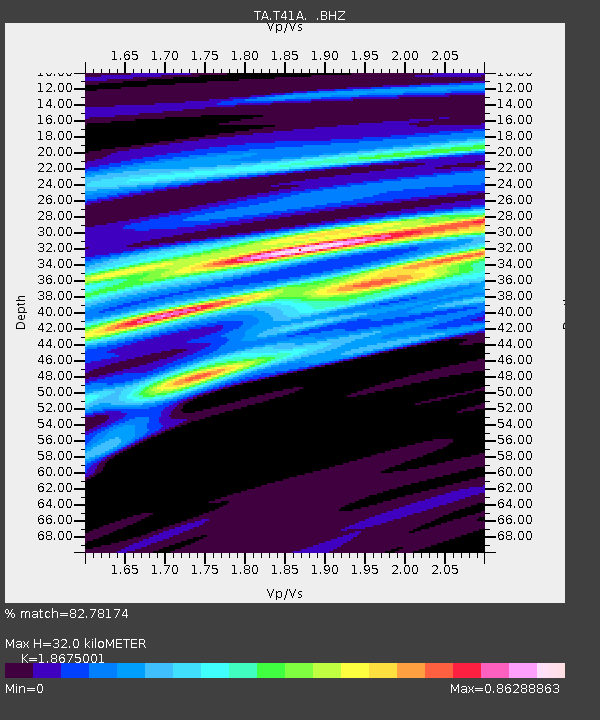
T41A Mountain View, MO, USA - Earthquake Result Viewer
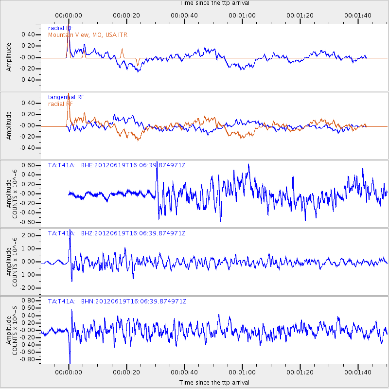
Earthquake location: Near Islands, Aleutian Islands
Earthquake latitude/longitude: 53.4/171.6
Earthquake time(UTC): 2012/06/19 (171) 15:56:32 GMT
Earthquake Depth: 14 km
Earthquake Magnitude: 6.2 MB, 5.7 MS, 6.0 MW, 6.1 MW
Earthquake Catalog/Contributor: WHDF/NEIC
Network: TA USArray Transportable Network (new EarthScope stations)
Station: T41A Mountain View, MO, USA
Lat/Lon: 37.04 N/91.76 W
Elevation: 366 m
Distance: 64.9 deg
Az: 61.396 deg
Baz: 318.867 deg
Ray Param: 0.058642756
Estimated Moho Depth: 32.0 km
Estimated Crust Vp/Vs: 1.87
Assumed Crust Vp: 6.53 km/s
Estimated Crust Vs: 3.497 km/s
Estimated Crust Poisson's Ratio: 0.30
Radial Match: 82.78174 %
Radial Bump: 400
Transverse Match: 55.245182 %
Transverse Bump: 400
SOD ConfigId: 460165
Insert Time: 2013-02-11 22:17:17.387 +0000
GWidth: 2.5
Max Bumps: 400
Tol: 0.001

Signal To Noise

ChannelStoNSTALTA
TA:T41A: :BHZ:20120619T16:06:39.874971Z10.7220147.54175E-77.033893E-8
TA:T41A: :BHN:20120619T16:06:39.874971Z4.35242842.6924903E-76.186179E-8
TA:T41A: :BHE:20120619T16:06:39.874971Z6.13043932.70751E-74.416502E-8
Arrivals
Ps4.4 SECOND
PpPs13 SECOND
PsPs/PpSs18 SECOND