O42A Bath, IL, USA - Earthquake Result Viewer
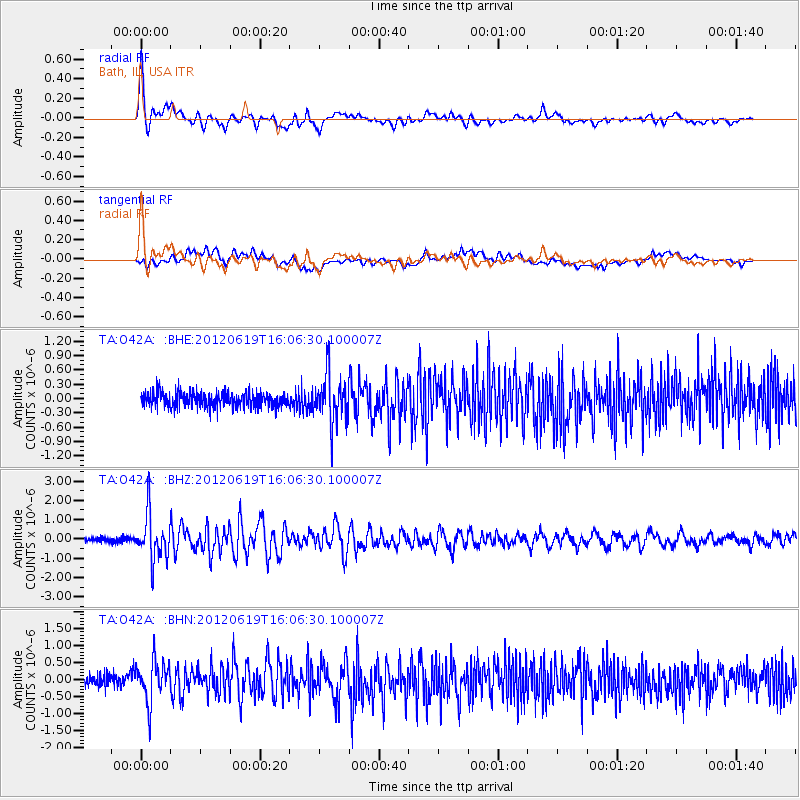
Earthquake location: Near Islands, Aleutian Islands
Earthquake latitude/longitude: 53.4/171.6
Earthquake time(UTC): 2012/06/19 (171) 15:56:32 GMT
Earthquake Depth: 14 km
Earthquake Magnitude: 6.2 MB, 5.7 MS, 6.0 MW, 6.1 MW
Earthquake Catalog/Contributor: WHDF/NEIC
Network: TA USArray Transportable Network (new EarthScope stations)
Station: O42A Bath, IL, USA
Lat/Lon: 40.20 N/90.08 W
Elevation: 155 m
Distance: 63.4 deg
Az: 57.985 deg
Baz: 318.424 deg
Ray Param: 0.05961348
Estimated Moho Depth: 39.5 km
Estimated Crust Vp/Vs: 1.65
Assumed Crust Vp: 6.498 km/s
Estimated Crust Vs: 3.932 km/s
Estimated Crust Poisson's Ratio: 0.21
Radial Match: 88.95884 %
Radial Bump: 400
Transverse Match: 71.29019 %
Transverse Bump: 400
SOD ConfigId: 460165
Insert Time: 2013-02-11 22:19:15.961 +0000
GWidth: 2.5
Max Bumps: 400
Tol: 0.001

Signal To Noise

ChannelStoNSTALTA
TA:O42A: :BHZ:20120619T16:06:30.100007Z10.160111.1762328E-61.1576969E-7
TA:O42A: :BHN:20120619T16:06:30.100007Z3.83698585.9670515E-71.5551403E-7
TA:O42A: :BHE:20120619T16:06:30.100007Z3.338195.0642416E-71.517062E-7
Arrivals
Ps4.2 SECOND
PpPs15 SECOND
PsPs/PpSs20 SECOND