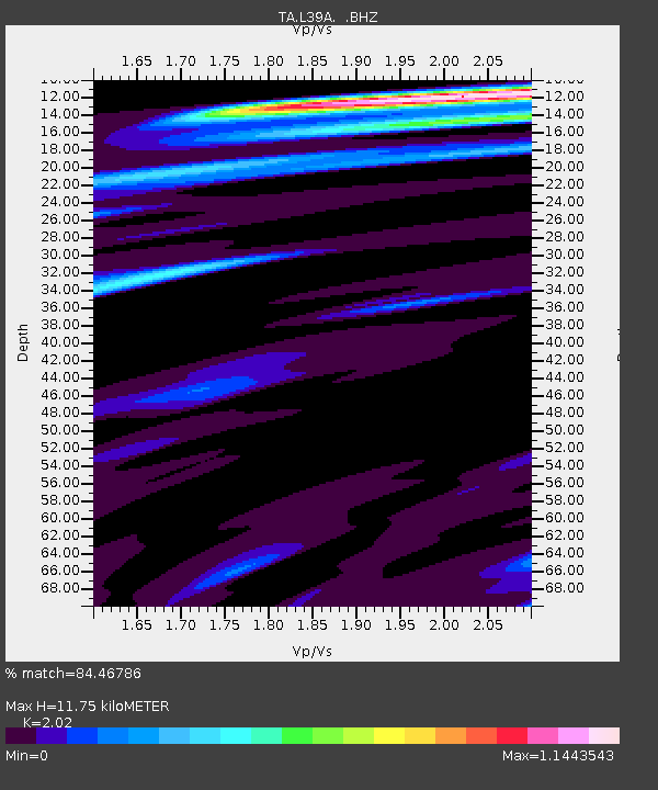
L39A Vinton, IA, USA - Earthquake Result Viewer
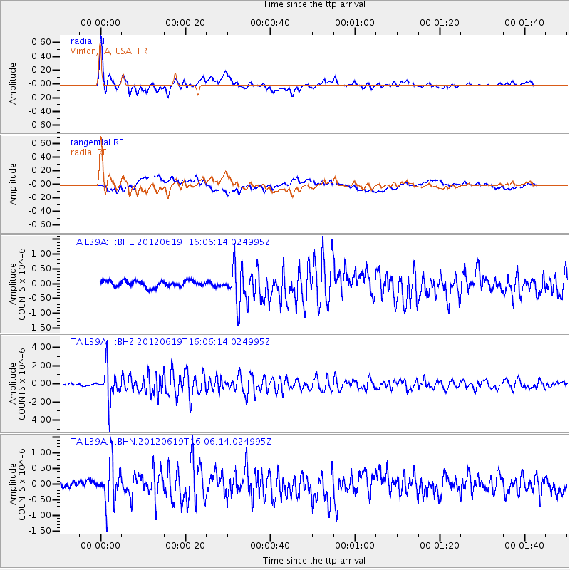
Earthquake location: Near Islands, Aleutian Islands
Earthquake latitude/longitude: 53.4/171.6
Earthquake time(UTC): 2012/06/19 (171) 15:56:32 GMT
Earthquake Depth: 14 km
Earthquake Magnitude: 6.2 MB, 5.7 MS, 6.0 MW, 6.1 MW
Earthquake Catalog/Contributor: WHDF/NEIC
Network: TA USArray Transportable Network (new EarthScope stations)
Station: L39A Vinton, IA, USA
Lat/Lon: 42.12 N/92.00 W
Elevation: 261 m
Distance: 61.0 deg
Az: 57.734 deg
Baz: 317.047 deg
Ray Param: 0.0611727
Estimated Moho Depth: 11.75 km
Estimated Crust Vp/Vs: 2.02
Assumed Crust Vp: 6.53 km/s
Estimated Crust Vs: 3.233 km/s
Estimated Crust Poisson's Ratio: 0.34
Radial Match: 84.46786 %
Radial Bump: 400
Transverse Match: 49.237995 %
Transverse Bump: 400
SOD ConfigId: 460165
Insert Time: 2013-02-11 22:19:27.527 +0000
GWidth: 2.5
Max Bumps: 400
Tol: 0.001

Signal To Noise

ChannelStoNSTALTA
TA:L39A: :BHZ:20120619T16:06:14.024995Z29.8027611.8007634E-66.04227E-8
TA:L39A: :BHN:20120619T16:06:14.024995Z3.59884296.8483877E-71.9029416E-7
TA:L39A: :BHE:20120619T16:06:14.024995Z6.61284546.725615E-71.0170532E-7
Arrivals
Ps1.9 SECOND
PpPs5.2 SECOND
PsPs/PpSs7.1 SECOND