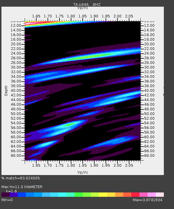
U44A Portageville, MO, USA - Earthquake Result Viewer
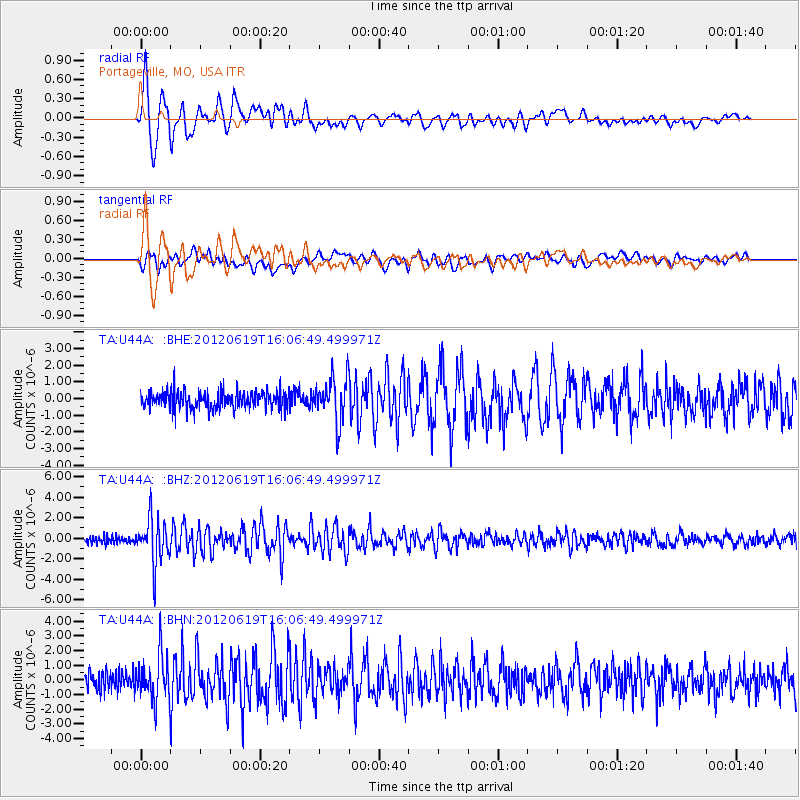
Earthquake location: Near Islands, Aleutian Islands
Earthquake latitude/longitude: 53.4/171.6
Earthquake time(UTC): 2012/06/19 (171) 15:56:32 GMT
Earthquake Depth: 14 km
Earthquake Magnitude: 6.2 MB, 5.7 MS, 6.0 MW, 6.1 MW
Earthquake Catalog/Contributor: WHDF/NEIC
Network: TA USArray Transportable Network (new EarthScope stations)
Station: U44A Portageville, MO, USA
Lat/Lon: 36.50 N/89.69 W
Elevation: 89 m
Distance: 66.4 deg
Az: 60.393 deg
Baz: 319.691 deg
Ray Param: 0.057661686
Estimated Moho Depth: 11.0 km
Estimated Crust Vp/Vs: 1.60
Assumed Crust Vp: 6.444 km/s
Estimated Crust Vs: 4.027 km/s
Estimated Crust Poisson's Ratio: 0.18
Radial Match: 93.824005 %
Radial Bump: 400
Transverse Match: 81.10729 %
Transverse Bump: 400
SOD ConfigId: 460165
Insert Time: 2013-02-11 22:20:51.401 +0000
GWidth: 2.5
Max Bumps: 400
Tol: 0.001

Signal To Noise

ChannelStoNSTALTA
TA:U44A: :BHZ:20120619T16:06:49.499971Z7.35856632.2397012E-63.0436652E-7
TA:U44A: :BHN:20120619T16:06:49.499971Z2.6862211.5224241E-65.6675316E-7
TA:U44A: :BHE:20120619T16:06:49.499971Z2.55897621.3343138E-65.2142485E-7
Arrivals
Ps1.1 SECOND
PpPs4.2 SECOND
PsPs/PpSs5.3 SECOND