You are here: Home > Network List > TA - USArray Transportable Network (new EarthScope stations) Stations List
> Station W42A Bald Knob, AR, USA > Earthquake Result Viewer
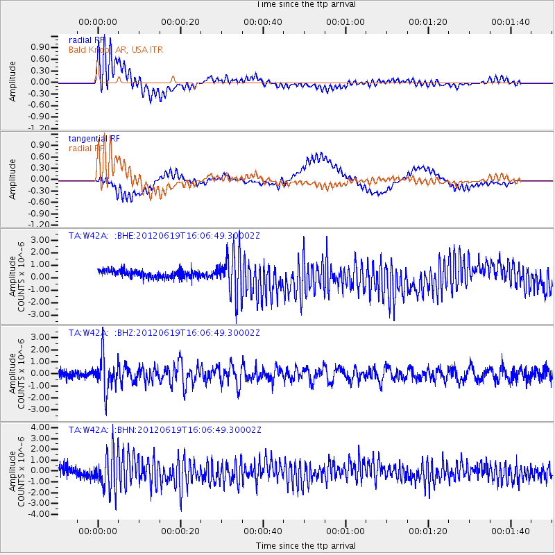
W42A Bald Knob, AR, USA - Earthquake Result Viewer
*The percent match for this event was below the threshold and hence no stack was calculated.
| Earthquake location: |
Near Islands, Aleutian Islands |
| Earthquake latitude/longitude: |
53.4/171.6 |
| Earthquake time(UTC): |
2012/06/19 (171) 15:56:32 GMT |
| Earthquake Depth: |
14 km |
| Earthquake Magnitude: |
6.2 MB, 5.7 MS, 6.0 MW, 6.1 MW |
| Earthquake Catalog/Contributor: |
WHDF/NEIC |
|
| Network: |
TA USArray Transportable Network (new EarthScope stations) |
| Station: |
W42A Bald Knob, AR, USA |
| Lat/Lon: |
35.27 N/91.52 W |
| Elevation: |
71 m |
|
| Distance: |
66.3 deg |
| Az: |
62.503 deg |
| Baz: |
319.466 deg |
| Ray Param: |
$rayparam |
*The percent match for this event was below the threshold and hence was not used in the summary stack. |
|
| Radial Match: |
76.519745 % |
| Radial Bump: |
400 |
| Transverse Match: |
41.822563 % |
| Transverse Bump: |
400 |
| SOD ConfigId: |
460165 |
| Insert Time: |
2013-02-11 22:21:03.142 +0000 |
| GWidth: |
2.5 |
| Max Bumps: |
400 |
| Tol: |
0.001 |
|
Signal To Noise
| Channel | StoN | STA | LTA |
| TA:W42A: :BHZ:20120619T16:06:49.30002Z | 6.996552 | 1.4338157E-6 | 2.0493175E-7 |
| TA:W42A: :BHN:20120619T16:06:49.30002Z | 5.3256025 | 1.7769831E-6 | 3.3366803E-7 |
| TA:W42A: :BHE:20120619T16:06:49.30002Z | 5.7973557 | 1.6955436E-6 | 2.9246846E-7 |
| Arrivals |
| Ps | |
| PpPs | |
| PsPs/PpSs | |


