I41A Arkdale, WI, USA - Earthquake Result Viewer
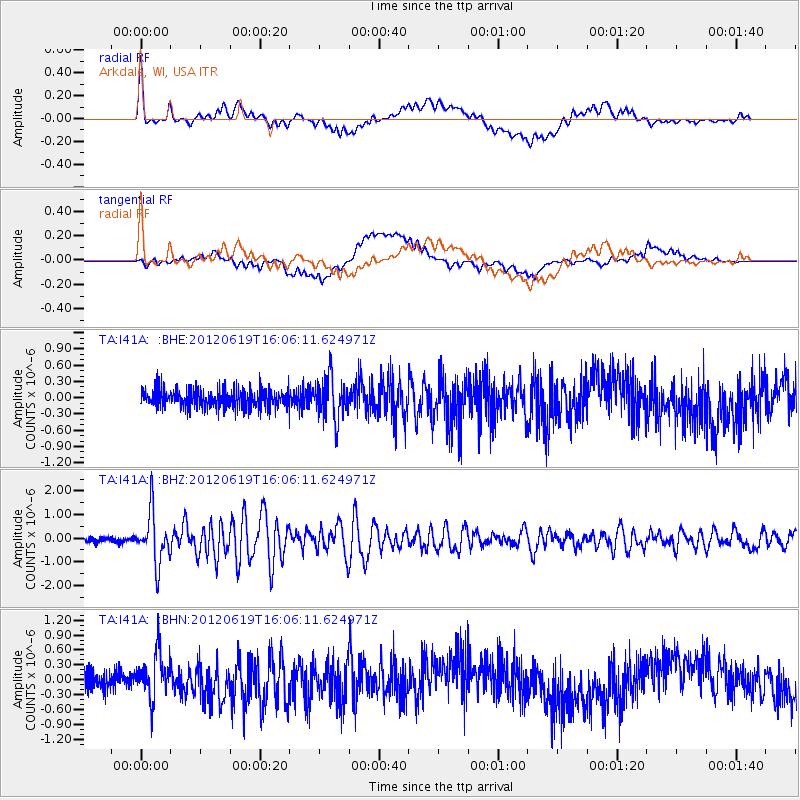
Earthquake location: Near Islands, Aleutian Islands
Earthquake latitude/longitude: 53.4/171.6
Earthquake time(UTC): 2012/06/19 (171) 15:56:32 GMT
Earthquake Depth: 14 km
Earthquake Magnitude: 6.2 MB, 5.7 MS, 6.0 MW, 6.1 MW
Earthquake Catalog/Contributor: WHDF/NEIC
Network: TA USArray Transportable Network (new EarthScope stations)
Station: I41A Arkdale, WI, USA
Lat/Lon: 44.06 N/89.87 W
Elevation: 289 m
Distance: 60.6 deg
Az: 54.915 deg
Baz: 317.122 deg
Ray Param: 0.0614067
Estimated Moho Depth: 41.0 km
Estimated Crust Vp/Vs: 1.75
Assumed Crust Vp: 6.41 km/s
Estimated Crust Vs: 3.674 km/s
Estimated Crust Poisson's Ratio: 0.26
Radial Match: 82.87888 %
Radial Bump: 400
Transverse Match: 39.58 %
Transverse Bump: 400
SOD ConfigId: 460165
Insert Time: 2013-02-11 22:21:26.508 +0000
GWidth: 2.5
Max Bumps: 400
Tol: 0.001

Signal To Noise

ChannelStoNSTALTA
TA:I41A: :BHZ:20120619T16:06:11.624971Z10.5491061.0869697E-61.0303905E-7
TA:I41A: :BHN:20120619T16:06:11.624971Z2.60933114.765404E-71.8262932E-7
TA:I41A: :BHE:20120619T16:06:11.624971Z2.30810713.8447607E-71.6657634E-7
Arrivals
Ps5.0 SECOND
PpPs17 SECOND
PsPs/PpSs22 SECOND