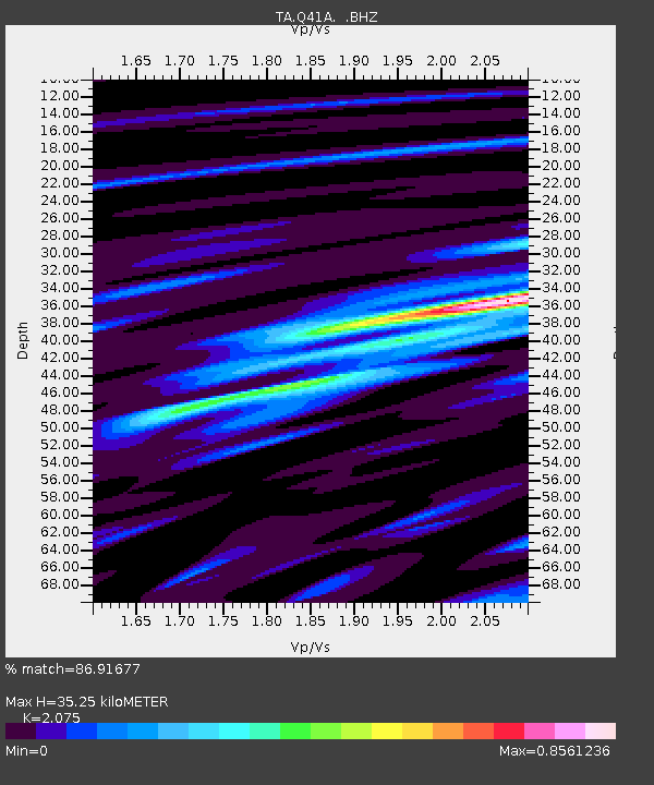
Q41A Truxton, MO, USA - Earthquake Result Viewer

Earthquake location: Near Islands, Aleutian Islands
Earthquake latitude/longitude: 53.4/171.6
Earthquake time(UTC): 2012/06/19 (171) 15:56:32 GMT
Earthquake Depth: 14 km
Earthquake Magnitude: 6.2 MB, 5.7 MS, 6.0 MW, 6.1 MW
Earthquake Catalog/Contributor: WHDF/NEIC
Network: TA USArray Transportable Network (new EarthScope stations)
Station: Q41A Truxton, MO, USA
Lat/Lon: 38.95 N/91.23 W
Elevation: 191 m
Distance: 63.7 deg
Az: 59.648 deg
Baz: 318.434 deg
Ray Param: 0.05939451
Estimated Moho Depth: 35.25 km
Estimated Crust Vp/Vs: 2.08
Assumed Crust Vp: 6.498 km/s
Estimated Crust Vs: 3.131 km/s
Estimated Crust Poisson's Ratio: 0.35
Radial Match: 86.91677 %
Radial Bump: 400
Transverse Match: 59.10371 %
Transverse Bump: 400
SOD ConfigId: 460165
Insert Time: 2013-02-11 22:21:50.357 +0000
GWidth: 2.5
Max Bumps: 400
Tol: 0.001

Signal To Noise

ChannelStoNSTALTA
TA:Q41A: :BHZ:20120619T16:06:32.324983Z24.9908561.275071E-65.10215E-8
TA:Q41A: :BHN:20120619T16:06:32.324983Z6.3055184.3545447E-76.905927E-8
TA:Q41A: :BHE:20120619T16:06:32.324983Z3.88076023.931093E-71.0129698E-7
Arrivals
Ps6.1 SECOND
PpPs16 SECOND
PsPs/PpSs22 SECOND