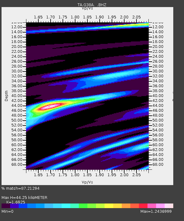
G38A Ridgeland, WI, USA - Earthquake Result Viewer

Earthquake location: Near Islands, Aleutian Islands
Earthquake latitude/longitude: 53.4/171.6
Earthquake time(UTC): 2012/06/19 (171) 15:56:32 GMT
Earthquake Depth: 14 km
Earthquake Magnitude: 6.2 MB, 5.7 MS, 6.0 MW, 6.1 MW
Earthquake Catalog/Contributor: WHDF/NEIC
Network: TA USArray Transportable Network (new EarthScope stations)
Station: G38A Ridgeland, WI, USA
Lat/Lon: 45.17 N/91.85 W
Elevation: 370 m
Distance: 58.8 deg
Az: 55.221 deg
Baz: 315.887 deg
Ray Param: 0.06257749
Estimated Moho Depth: 44.25 km
Estimated Crust Vp/Vs: 1.69
Assumed Crust Vp: 6.571 km/s
Estimated Crust Vs: 3.882 km/s
Estimated Crust Poisson's Ratio: 0.23
Radial Match: 87.21294 %
Radial Bump: 400
Transverse Match: 73.45336 %
Transverse Bump: 400
SOD ConfigId: 460165
Insert Time: 2013-02-11 22:22:39.450 +0000
GWidth: 2.5
Max Bumps: 400
Tol: 0.001

Signal To Noise

ChannelStoNSTALTA
TA:G38A: :BHZ:20120619T16:05:59.399995Z23.3390331.0991515E-64.7094986E-8
TA:G38A: :BHN:20120619T16:05:59.399995Z3.22474743.4452484E-71.0683778E-7
TA:G38A: :BHE:20120619T16:05:59.399995Z6.16678244.208672E-76.824746E-8
Arrivals
Ps4.9 SECOND
PpPs17 SECOND
PsPs/PpSs22 SECOND