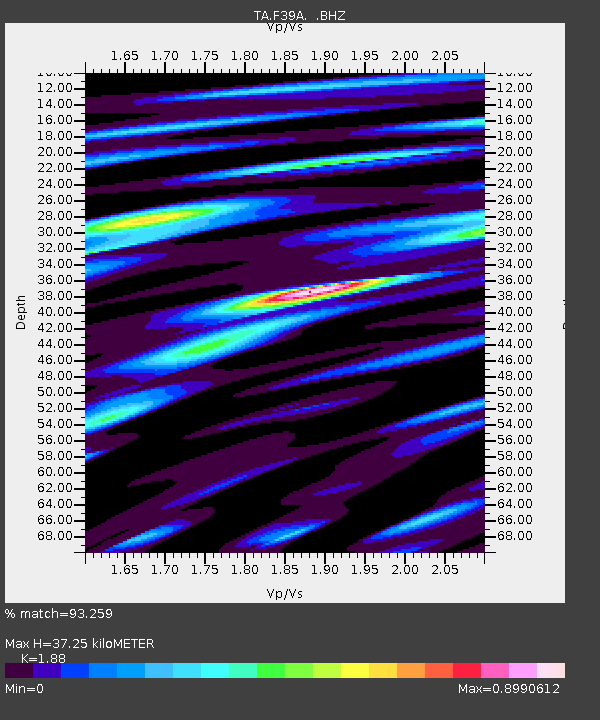
F39A Loretta, WI, USA - Earthquake Result Viewer
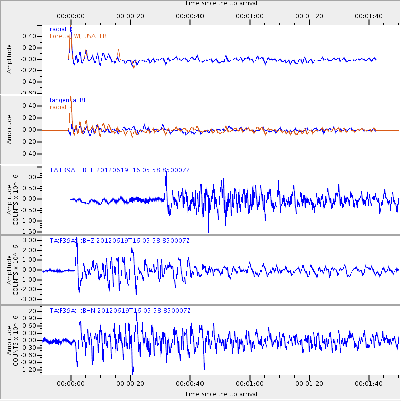
Earthquake location: Near Islands, Aleutian Islands
Earthquake latitude/longitude: 53.4/171.6
Earthquake time(UTC): 2012/06/19 (171) 15:56:32 GMT
Earthquake Depth: 14 km
Earthquake Magnitude: 6.2 MB, 5.7 MS, 6.0 MW, 6.1 MW
Earthquake Catalog/Contributor: WHDF/NEIC
Network: TA USArray Transportable Network (new EarthScope stations)
Station: F39A Loretta, WI, USA
Lat/Lon: 45.92 N/90.92 W
Elevation: 440 m
Distance: 58.8 deg
Az: 54.062 deg
Baz: 315.952 deg
Ray Param: 0.06262858
Estimated Moho Depth: 37.25 km
Estimated Crust Vp/Vs: 1.88
Assumed Crust Vp: 6.571 km/s
Estimated Crust Vs: 3.495 km/s
Estimated Crust Poisson's Ratio: 0.30
Radial Match: 93.259 %
Radial Bump: 400
Transverse Match: 84.52808 %
Transverse Bump: 400
SOD ConfigId: 460165
Insert Time: 2013-02-11 22:24:17.396 +0000
GWidth: 2.5
Max Bumps: 400
Tol: 0.001

Signal To Noise

ChannelStoNSTALTA
TA:F39A: :BHZ:20120619T16:05:58.850007Z13.3689911.1430645E-68.5501185E-8
TA:F39A: :BHN:20120619T16:05:58.850007Z5.99119333.8711536E-76.461406E-8
TA:F39A: :BHE:20120619T16:05:58.850007Z5.9354694.034959E-76.798046E-8
Arrivals
Ps5.2 SECOND
PpPs16 SECOND
PsPs/PpSs21 SECOND