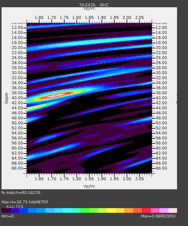
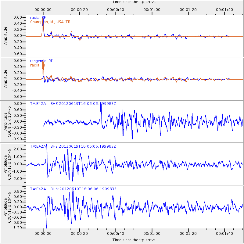
E42A Champion, MI, USA - Earthquake Result Viewer

Earthquake location: Near Islands, Aleutian Islands
Earthquake latitude/longitude: 53.4/171.6
Earthquake time(UTC): 2012/06/19 (171) 15:56:32 GMT
Earthquake Depth: 14 km
Earthquake Magnitude: 6.2 MB, 5.7 MS, 6.0 MW, 6.1 MW
Earthquake Catalog/Contributor: WHDF/NEIC
Network: TA USArray Transportable Network (new EarthScope stations)
Station: E42A Champion, MI, USA
Lat/Lon: 46.43 N/87.91 W
Elevation: 475 m
Distance: 59.8 deg
Az: 51.888 deg
Baz: 317.003 deg
Ray Param: 0.061928634
Estimated Moho Depth: 38.75 km
Estimated Crust Vp/Vs: 1.72
Assumed Crust Vp: 6.472 km/s
Estimated Crust Vs: 3.774 km/s
Estimated Crust Poisson's Ratio: 0.24
Radial Match: 90.06235 %
Radial Bump: 328
Transverse Match: 77.5395 %
Transverse Bump: 400
SOD ConfigId: 460165
Insert Time: 2013-02-11 22:24:28.466 +0000
GWidth: 2.5
Max Bumps: 400
Tol: 0.001

Signal To Noise

ChannelStoNSTALTA
TA:E42A: :BHZ:20120619T16:06:06.199983Z10.9055171.0196571E-69.349921E-8
TA:E42A: :BHN:20120619T16:06:06.199983Z7.53406764.639549E-76.1580934E-8
TA:E42A: :BHE:20120619T16:06:06.199983Z5.4391753.3310758E-76.12423E-8
Arrivals
Ps4.5 SECOND
PpPs15 SECOND
PsPs/PpSs20 SECOND