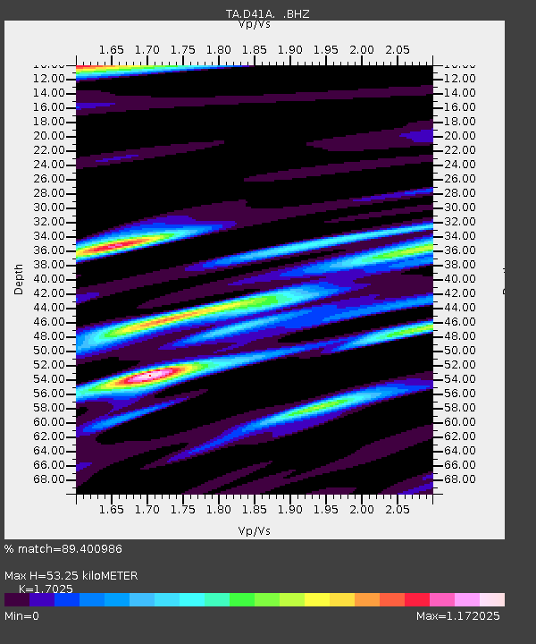
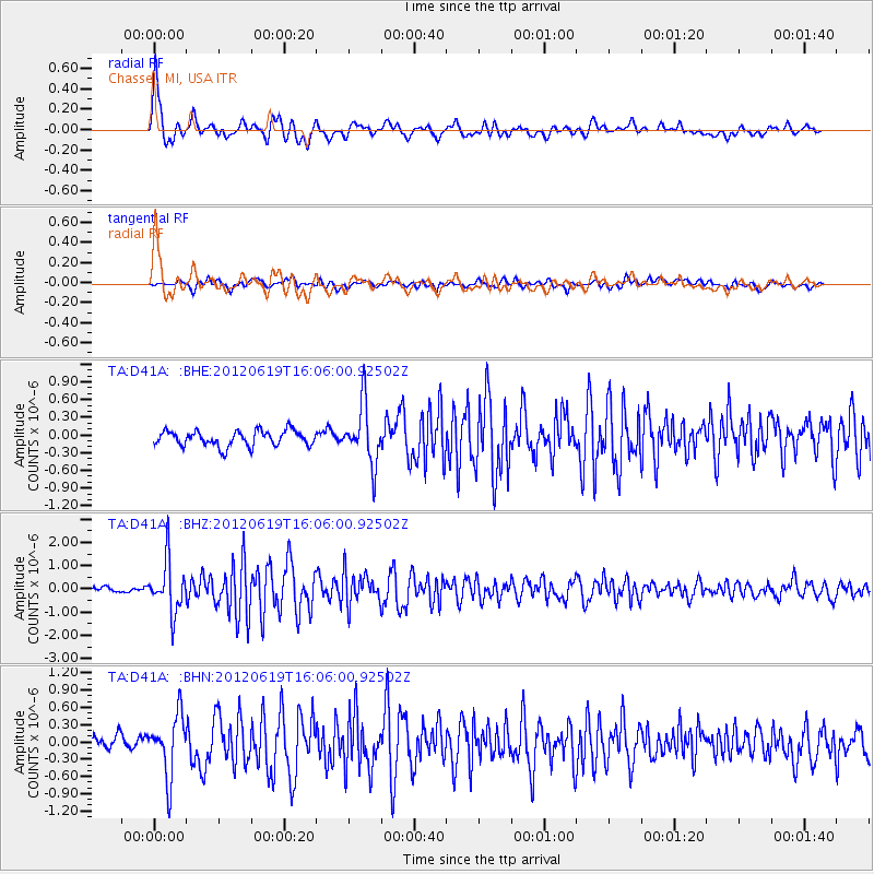
D41A Chassel, MI, USA - Earthquake Result Viewer

Earthquake location: Near Islands, Aleutian Islands
Earthquake latitude/longitude: 53.4/171.6
Earthquake time(UTC): 2012/06/19 (171) 15:56:32 GMT
Earthquake Depth: 14 km
Earthquake Magnitude: 6.2 MB, 5.7 MS, 6.0 MW, 6.1 MW
Earthquake Catalog/Contributor: WHDF/NEIC
Network: TA USArray Transportable Network (new EarthScope stations)
Station: D41A Chassel, MI, USA
Lat/Lon: 47.06 N/88.57 W
Elevation: 271 m
Distance: 59.1 deg
Az: 51.765 deg
Baz: 316.468 deg
Ray Param: 0.06243362
Estimated Moho Depth: 53.25 km
Estimated Crust Vp/Vs: 1.70
Assumed Crust Vp: 6.467 km/s
Estimated Crust Vs: 3.798 km/s
Estimated Crust Poisson's Ratio: 0.24
Radial Match: 89.400986 %
Radial Bump: 400
Transverse Match: 64.563576 %
Transverse Bump: 400
SOD ConfigId: 460165
Insert Time: 2013-02-11 22:24:41.126 +0000
GWidth: 2.5
Max Bumps: 400
Tol: 0.001

Signal To Noise

ChannelStoNSTALTA
TA:D41A: :BHZ:20120619T16:06:00.92502Z6.9375241.1028886E-61.5897439E-7
TA:D41A: :BHN:20120619T16:06:00.92502Z4.15340955.264752E-71.2675737E-7
TA:D41A: :BHE:20120619T16:06:00.92502Z3.83668115.004619E-71.3044136E-7
Arrivals
Ps6.1 SECOND
PpPs21 SECOND
PsPs/PpSs27 SECOND