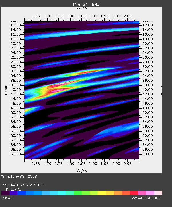
G43A Wallace, MI, USA - Earthquake Result Viewer
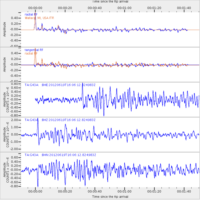
Earthquake location: Near Islands, Aleutian Islands
Earthquake latitude/longitude: 53.4/171.6
Earthquake time(UTC): 2012/06/19 (171) 15:56:32 GMT
Earthquake Depth: 14 km
Earthquake Magnitude: 6.2 MB, 5.7 MS, 6.0 MW, 6.1 MW
Earthquake Catalog/Contributor: WHDF/NEIC
Network: TA USArray Transportable Network (new EarthScope stations)
Station: G43A Wallace, MI, USA
Lat/Lon: 45.26 N/87.69 W
Elevation: 213 m
Distance: 60.8 deg
Az: 52.67 deg
Baz: 317.553 deg
Ray Param: 0.061290782
Estimated Moho Depth: 36.75 km
Estimated Crust Vp/Vs: 1.77
Assumed Crust Vp: 6.53 km/s
Estimated Crust Vs: 3.679 km/s
Estimated Crust Poisson's Ratio: 0.27
Radial Match: 83.40528 %
Radial Bump: 400
Transverse Match: 71.29366 %
Transverse Bump: 400
SOD ConfigId: 460165
Insert Time: 2013-02-11 22:24:41.824 +0000
GWidth: 2.5
Max Bumps: 400
Tol: 0.001

Signal To Noise

ChannelStoNSTALTA
TA:G43A: :BHZ:20120619T16:06:12.824983Z7.4062597.861919E-71.0615236E-7
TA:G43A: :BHN:20120619T16:06:12.824983Z3.6273922.5360129E-76.991284E-8
TA:G43A: :BHE:20120619T16:06:12.824983Z4.30677032.9036357E-76.742026E-8
Arrivals
Ps4.6 SECOND
PpPs15 SECOND
PsPs/PpSs19 SECOND