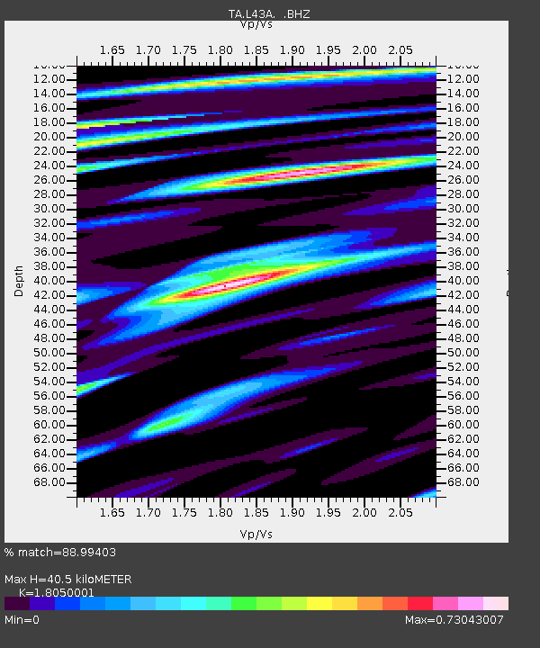
L43A Garden Prairie, IL, USA - Earthquake Result Viewer
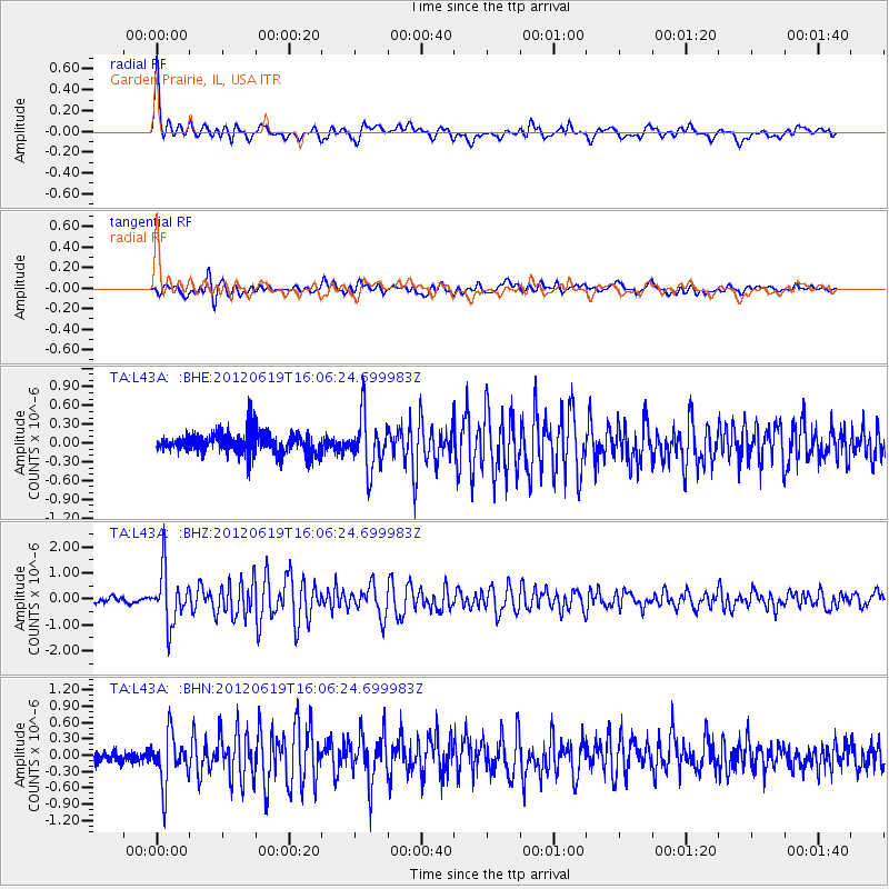
Earthquake location: Near Islands, Aleutian Islands
Earthquake latitude/longitude: 53.4/171.6
Earthquake time(UTC): 2012/06/19 (171) 15:56:32 GMT
Earthquake Depth: 14 km
Earthquake Magnitude: 6.2 MB, 5.7 MS, 6.0 MW, 6.1 MW
Earthquake Catalog/Contributor: WHDF/NEIC
Network: TA USArray Transportable Network (new EarthScope stations)
Station: L43A Garden Prairie, IL, USA
Lat/Lon: 42.18 N/88.74 W
Elevation: 266 m
Distance: 62.6 deg
Az: 55.656 deg
Baz: 318.243 deg
Ray Param: 0.06013902
Estimated Moho Depth: 40.5 km
Estimated Crust Vp/Vs: 1.81
Assumed Crust Vp: 6.571 km/s
Estimated Crust Vs: 3.64 km/s
Estimated Crust Poisson's Ratio: 0.28
Radial Match: 88.99403 %
Radial Bump: 400
Transverse Match: 76.98154 %
Transverse Bump: 400
SOD ConfigId: 460165
Insert Time: 2013-02-11 22:24:53.911 +0000
GWidth: 2.5
Max Bumps: 400
Tol: 0.001

Signal To Noise

ChannelStoNSTALTA
TA:L43A: :BHZ:20120619T16:06:24.699983Z12.7262111.0217624E-68.028803E-8
TA:L43A: :BHN:20120619T16:06:24.699983Z3.85412864.5660903E-71.18472705E-7
TA:L43A: :BHE:20120619T16:06:24.699983Z2.45188644.0847462E-71.6659607E-7
Arrivals
Ps5.2 SECOND
PpPs17 SECOND
PsPs/PpSs22 SECOND