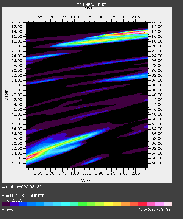
N45A Kentland, IN, USA - Earthquake Result Viewer
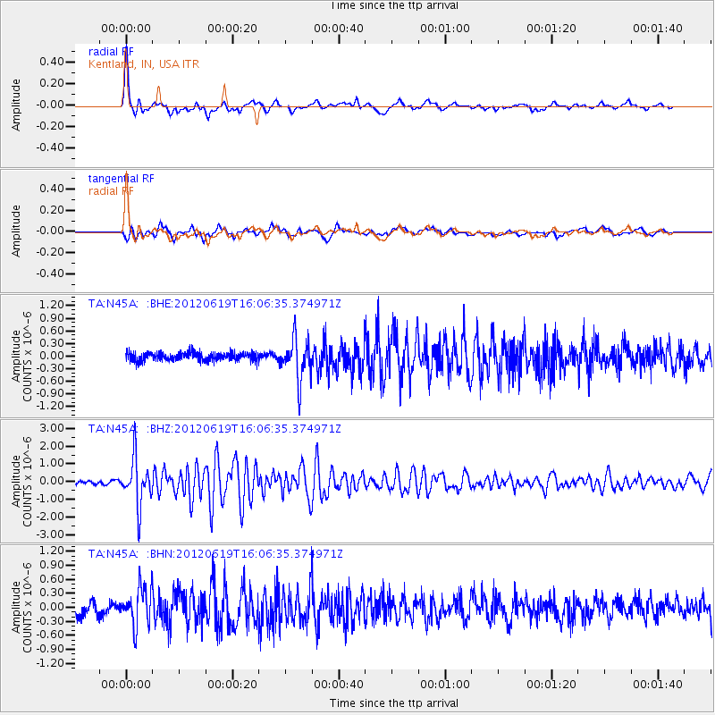
Earthquake location: Near Islands, Aleutian Islands
Earthquake latitude/longitude: 53.4/171.6
Earthquake time(UTC): 2012/06/19 (171) 15:56:32 GMT
Earthquake Depth: 14 km
Earthquake Magnitude: 6.2 MB, 5.7 MS, 6.0 MW, 6.1 MW
Earthquake Catalog/Contributor: WHDF/NEIC
Network: TA USArray Transportable Network (new EarthScope stations)
Station: N45A Kentland, IN, USA
Lat/Lon: 40.85 N/87.51 W
Elevation: 206 m
Distance: 64.2 deg
Az: 55.864 deg
Baz: 319.149 deg
Ray Param: 0.059087552
Estimated Moho Depth: 14.0 km
Estimated Crust Vp/Vs: 2.09
Assumed Crust Vp: 6.498 km/s
Estimated Crust Vs: 3.116 km/s
Estimated Crust Poisson's Ratio: 0.35
Radial Match: 90.158485 %
Radial Bump: 400
Transverse Match: 80.08061 %
Transverse Bump: 400
SOD ConfigId: 460165
Insert Time: 2013-02-11 22:26:16.960 +0000
GWidth: 2.5
Max Bumps: 400
Tol: 0.001

Signal To Noise

ChannelStoNSTALTA
TA:N45A: :BHZ:20120619T16:06:35.374971Z16.3111671.3383483E-68.2051045E-8
TA:N45A: :BHN:20120619T16:06:35.374971Z3.63204244.1671748E-71.1473365E-7
TA:N45A: :BHE:20120619T16:06:35.374971Z5.06099944.9288826E-79.738951E-8
Arrivals
Ps2.4 SECOND
PpPs6.4 SECOND
PsPs/PpSs8.8 SECOND