You are here: Home > Network List > TA - USArray Transportable Network (new EarthScope stations) Stations List
> Station N46A Monticello, IN, USA > Earthquake Result Viewer
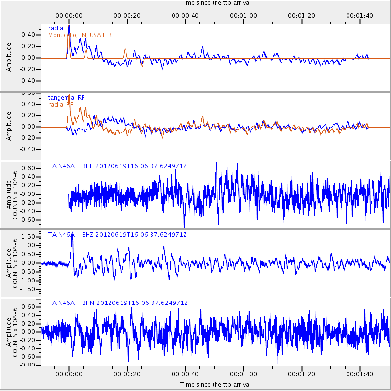
N46A Monticello, IN, USA - Earthquake Result Viewer
*The percent match for this event was below the threshold and hence no stack was calculated.
| Earthquake location: |
Near Islands, Aleutian Islands |
| Earthquake latitude/longitude: |
53.4/171.6 |
| Earthquake time(UTC): |
2012/06/19 (171) 15:56:32 GMT |
| Earthquake Depth: |
14 km |
| Earthquake Magnitude: |
6.2 MB, 5.7 MS, 6.0 MW, 6.1 MW |
| Earthquake Catalog/Contributor: |
WHDF/NEIC |
|
| Network: |
TA USArray Transportable Network (new EarthScope stations) |
| Station: |
N46A Monticello, IN, USA |
| Lat/Lon: |
40.89 N/86.74 W |
| Elevation: |
209 m |
|
| Distance: |
64.5 deg |
| Az: |
55.335 deg |
| Baz: |
319.426 deg |
| Ray Param: |
$rayparam |
*The percent match for this event was below the threshold and hence was not used in the summary stack. |
|
| Radial Match: |
74.68972 % |
| Radial Bump: |
400 |
| Transverse Match: |
70.19861 % |
| Transverse Bump: |
400 |
| SOD ConfigId: |
460165 |
| Insert Time: |
2013-02-11 22:26:28.434 +0000 |
| GWidth: |
2.5 |
| Max Bumps: |
400 |
| Tol: |
0.001 |
|
Signal To Noise
| Channel | StoN | STA | LTA |
| TA:N46A: :BHZ:20120619T16:06:37.624971Z | 7.2620673 | 6.1873993E-7 | 8.520162E-8 |
| TA:N46A: :BHN:20120619T16:06:37.624971Z | 1.5259358 | 2.3433724E-7 | 1.5356952E-7 |
| TA:N46A: :BHE:20120619T16:06:37.624971Z | 1.4440625 | 1.9907472E-7 | 1.3785743E-7 |
| Arrivals |
| Ps | |
| PpPs | |
| PsPs/PpSs | |


