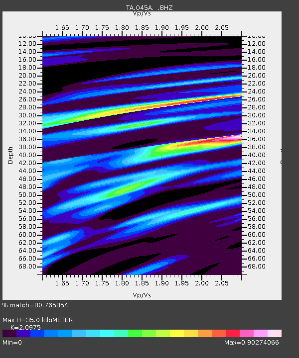
O45A Potomac, IL, USA - Earthquake Result Viewer
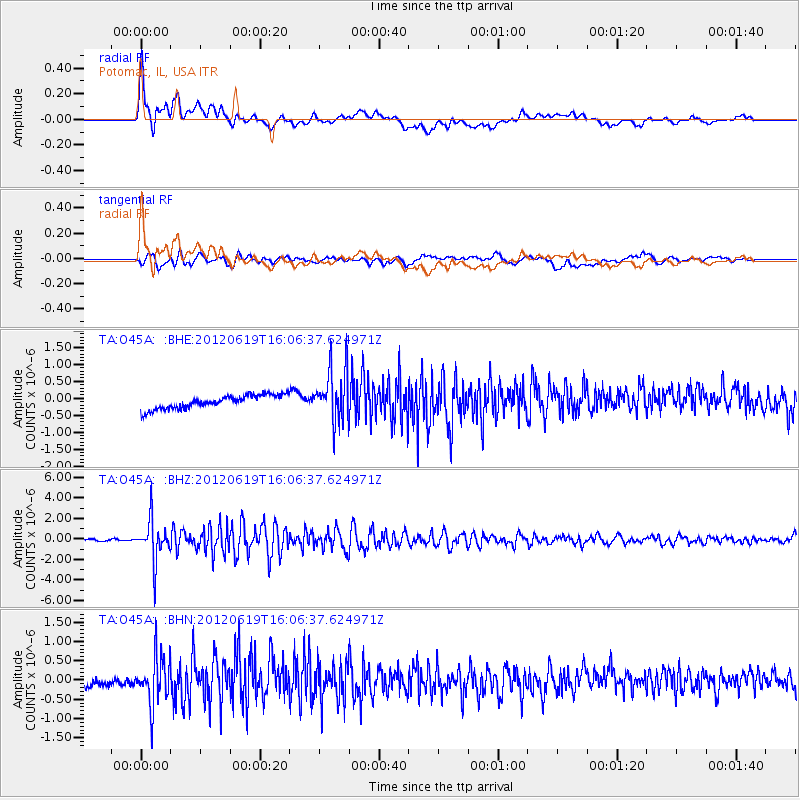
Earthquake location: Near Islands, Aleutian Islands
Earthquake latitude/longitude: 53.4/171.6
Earthquake time(UTC): 2012/06/19 (171) 15:56:32 GMT
Earthquake Depth: 14 km
Earthquake Magnitude: 6.2 MB, 5.7 MS, 6.0 MW, 6.1 MW
Earthquake Catalog/Contributor: WHDF/NEIC
Network: TA USArray Transportable Network (new EarthScope stations)
Station: O45A Potomac, IL, USA
Lat/Lon: 40.25 N/87.72 W
Elevation: 208 m
Distance: 64.5 deg
Az: 56.434 deg
Baz: 319.258 deg
Ray Param: 0.05886361
Estimated Moho Depth: 35.0 km
Estimated Crust Vp/Vs: 2.10
Assumed Crust Vp: 6.498 km/s
Estimated Crust Vs: 3.098 km/s
Estimated Crust Poisson's Ratio: 0.35
Radial Match: 80.765854 %
Radial Bump: 400
Transverse Match: 60.91262 %
Transverse Bump: 400
SOD ConfigId: 460165
Insert Time: 2013-02-11 22:26:52.217 +0000
GWidth: 2.5
Max Bumps: 400
Tol: 0.001

Signal To Noise

ChannelStoNSTALTA
TA:O45A: :BHZ:20120619T16:06:37.624971Z26.4530451.9828592E-67.495769E-8
TA:O45A: :BHN:20120619T16:06:37.624971Z6.02498346.2037867E-71.029677E-7
TA:O45A: :BHE:20120619T16:06:37.624971Z3.82246527.680307E-72.009255E-7
Arrivals
Ps6.1 SECOND
PpPs16 SECOND
PsPs/PpSs22 SECOND