You are here: Home > Network List > TA - USArray Transportable Network (new EarthScope stations) Stations List
> Station N43A Stutzman Family Farm, Minonk, IL, USA > Earthquake Result Viewer
N43A Stutzman Family Farm, Minonk, IL, USA - Earthquake Result Viewer
| Earthquake location: |
Near Islands, Aleutian Islands |
| Earthquake latitude/longitude: |
53.4/171.6 |
| Earthquake time(UTC): |
2012/06/19 (171) 15:56:32 GMT |
| Earthquake Depth: |
14 km |
| Earthquake Magnitude: |
6.2 MB, 5.7 MS, 6.0 MW, 6.1 MW |
| Earthquake Catalog/Contributor: |
WHDF/NEIC |
|
| Network: |
TA USArray Transportable Network (new EarthScope stations) |
| Station: |
N43A Stutzman Family Farm, Minonk, IL, USA |
| Lat/Lon: |
40.94 N/89.17 W |
| Elevation: |
215 m |
|
| Distance: |
63.3 deg |
| Az: |
56.855 deg |
| Baz: |
318.504 deg |
| Ray Param: |
0.0596767 |
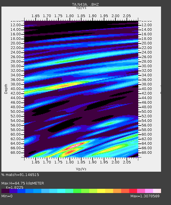
| Estimated Moho Depth: |
64.75 km |
| Estimated Crust Vp/Vs: |
1.82 |
| Assumed Crust Vp: |
6.498 km/s |
| Estimated Crust Vs: |
3.565 km/s |
| Estimated Crust Poisson's Ratio: |
0.28 |
|
| Radial Match: |
91.146515 % |
| Radial Bump: |
400 |
| Transverse Match: |
70.35354 % |
| Transverse Bump: |
400 |
| SOD ConfigId: |
460165 |
| Insert Time: |
2013-02-11 22:27:38.046 +0000 |
| GWidth: |
2.5 |
| Max Bumps: |
400 |
| Tol: |
0.001 |
|
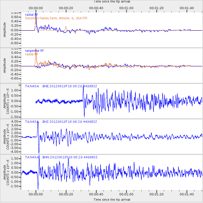
Signal To Noise
| Channel | StoN | STA | LTA |
| TA:N43A: :BHZ:20120619T16:06:29.449983Z | 18.189754 | 1.559736E-6 | 8.574805E-8 |
| TA:N43A: :BHN:20120619T16:06:29.449983Z | 5.1335278 | 6.655232E-7 | 1.2964247E-7 |
| TA:N43A: :BHE:20120619T16:06:29.449983Z | 5.778489 | 5.674193E-7 | 9.81951E-8 |
| Arrivals |
| Ps | 8.6 SECOND |
| PpPs | 27 SECOND |
| PsPs/PpSs | 35 SECOND |


