You are here: Home > Network List > TA - USArray Transportable Network (new EarthScope stations) Stations List
> Station R46A Gibon Southern Titans, Haubstabt, IN, USA > Earthquake Result Viewer
R46A Gibon Southern Titans, Haubstabt, IN, USA - Earthquake Result Viewer
| Earthquake location: |
Near Islands, Aleutian Islands |
| Earthquake latitude/longitude: |
53.4/171.6 |
| Earthquake time(UTC): |
2012/06/19 (171) 15:56:32 GMT |
| Earthquake Depth: |
14 km |
| Earthquake Magnitude: |
6.2 MB, 5.7 MS, 6.0 MW, 6.1 MW |
| Earthquake Catalog/Contributor: |
WHDF/NEIC |
|
| Network: |
TA USArray Transportable Network (new EarthScope stations) |
| Station: |
R46A Gibon Southern Titans, Haubstabt, IN, USA |
| Lat/Lon: |
38.21 N/87.51 W |
| Elevation: |
164 m |
|
| Distance: |
66.2 deg |
| Az: |
57.746 deg |
| Baz: |
319.94 deg |
| Ray Param: |
0.05778198 |
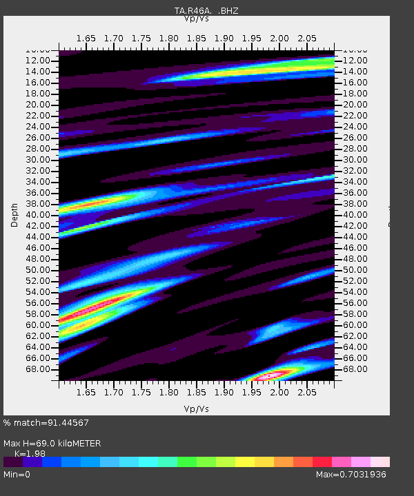
| Estimated Moho Depth: |
69.0 km |
| Estimated Crust Vp/Vs: |
1.98 |
| Assumed Crust Vp: |
6.444 km/s |
| Estimated Crust Vs: |
3.254 km/s |
| Estimated Crust Poisson's Ratio: |
0.33 |
|
| Radial Match: |
91.44567 % |
| Radial Bump: |
400 |
| Transverse Match: |
82.30629 % |
| Transverse Bump: |
400 |
| SOD ConfigId: |
460165 |
| Insert Time: |
2013-02-11 22:27:54.000 +0000 |
| GWidth: |
2.5 |
| Max Bumps: |
400 |
| Tol: |
0.001 |
|

Signal To Noise
| Channel | StoN | STA | LTA |
| TA:R46A: :BHZ:20120619T16:06:48.350007Z | 15.713801 | 1.378832E-6 | 8.7746564E-8 |
| TA:R46A: :BHN:20120619T16:06:48.350007Z | 5.4428816 | 4.858111E-7 | 8.925623E-8 |
| TA:R46A: :BHE:20120619T16:06:48.350007Z | 3.8719842 | 3.9086E-7 | 1.00945655E-7 |
| Arrivals |
| Ps | 11 SECOND |
| PpPs | 31 SECOND |
| PsPs/PpSs | 42 SECOND |


