T46A Princeton, KY, USA - Earthquake Result Viewer
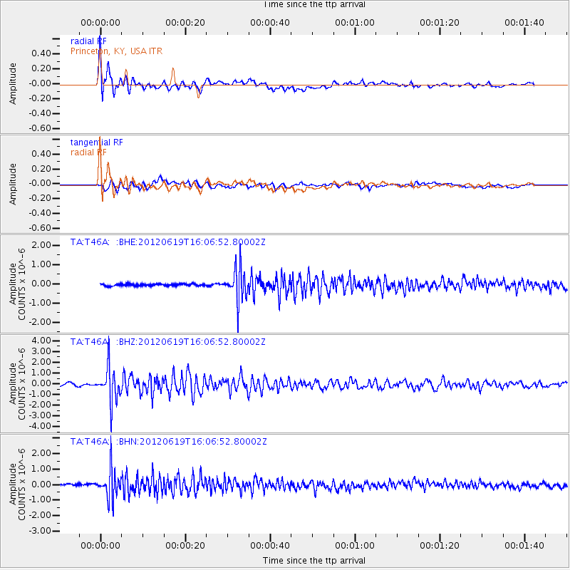
Earthquake location: Near Islands, Aleutian Islands
Earthquake latitude/longitude: 53.4/171.6
Earthquake time(UTC): 2012/06/19 (171) 15:56:32 GMT
Earthquake Depth: 14 km
Earthquake Magnitude: 6.2 MB, 5.7 MS, 6.0 MW, 6.1 MW
Earthquake Catalog/Contributor: WHDF/NEIC
Network: TA USArray Transportable Network (new EarthScope stations)
Station: T46A Princeton, KY, USA
Lat/Lon: 37.04 N/87.89 W
Elevation: 169 m
Distance: 66.9 deg
Az: 58.818 deg
Baz: 320.134 deg
Ray Param: 0.05731892
Estimated Moho Depth: 10.75 km
Estimated Crust Vp/Vs: 2.10
Assumed Crust Vp: 6.444 km/s
Estimated Crust Vs: 3.072 km/s
Estimated Crust Poisson's Ratio: 0.35
Radial Match: 88.87999 %
Radial Bump: 400
Transverse Match: 72.719666 %
Transverse Bump: 400
SOD ConfigId: 460165
Insert Time: 2013-02-11 22:28:12.904 +0000
GWidth: 2.5
Max Bumps: 400
Tol: 0.001

Signal To Noise

ChannelStoNSTALTA
TA:T46A: :BHZ:20120619T16:06:52.80002Z15.7915831.5558322E-69.852288E-8
TA:T46A: :BHN:20120619T16:06:52.80002Z12.4012189.0927244E-77.332122E-8
TA:T46A: :BHE:20120619T16:06:52.80002Z17.0393948.498308E-74.9874476E-8
Arrivals
Ps1.9 SECOND
PpPs5.0 SECOND
PsPs/PpSs6.9 SECOND