U47A Clarksville, TN, USA - Earthquake Result Viewer
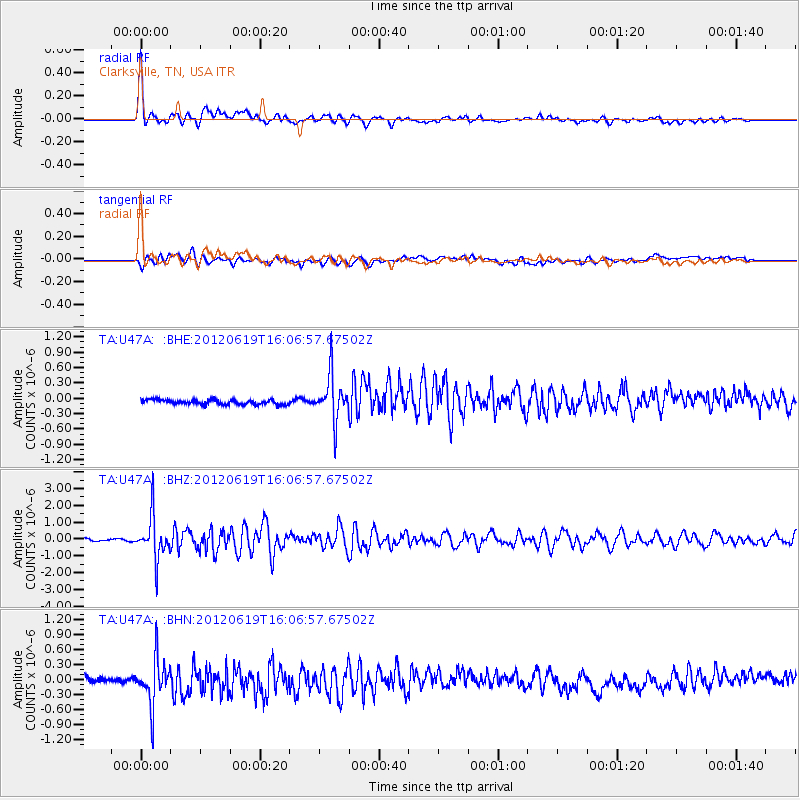
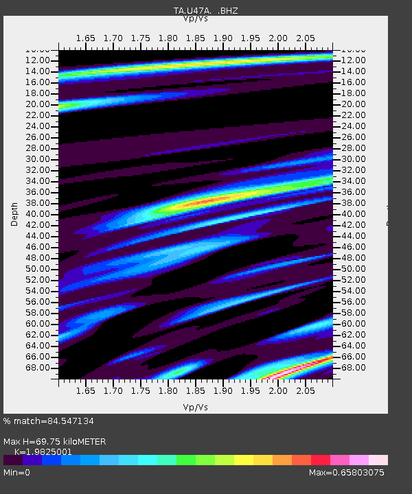
Earthquake location: Near Islands, Aleutian Islands
Earthquake latitude/longitude: 53.4/171.6
Earthquake time(UTC): 2012/06/19 (171) 15:56:32 GMT
Earthquake Depth: 14 km
Earthquake Magnitude: 6.2 MB, 5.7 MS, 6.0 MW, 6.1 MW
Earthquake Catalog/Contributor: WHDF/NEIC
Network: TA USArray Transportable Network (new EarthScope stations)
Station: U47A Clarksville, TN, USA
Lat/Lon: 36.44 N/87.29 W
Elevation: 145 m
Distance: 67.6 deg
Az: 58.827 deg
Baz: 320.498 deg
Ray Param: 0.056813903
Estimated Moho Depth: 69.75 km
Estimated Crust Vp/Vs: 1.98
Assumed Crust Vp: 6.444 km/s
Estimated Crust Vs: 3.25 km/s
Estimated Crust Poisson's Ratio: 0.33
Radial Match: 84.547134 %
Radial Bump: 400
Transverse Match: 78.45761 %
Transverse Bump: 400
SOD ConfigId: 460165
Insert Time: 2013-02-11 22:28:43.783 +0000
GWidth: 2.5
Max Bumps: 400
Tol: 0.001

Signal To Noise

ChannelStoNSTALTA
TA:U47A: :BHZ:20120619T16:06:57.67502Z22.0186461.232069E-65.595571E-8
TA:U47A: :BHN:20120619T16:06:57.67502Z5.9972254.5563564E-77.597441E-8
TA:U47A: :BHE:20120619T16:06:57.67502Z9.4013594.270687E-74.5426276E-8
Arrivals
Ps11 SECOND
PpPs31 SECOND
PsPs/PpSs42 SECOND