You are here: Home > Network List > TA - USArray Transportable Network (new EarthScope stations) Stations List
> Station R48A Northridge Ranch, Floyd Knobs, IN, USA > Earthquake Result Viewer
R48A Northridge Ranch, Floyd Knobs, IN, USA - Earthquake Result Viewer

| Earthquake location: |
Near Islands, Aleutian Islands |
| Earthquake latitude/longitude: |
53.4/171.6 |
| Earthquake time(UTC): |
2012/06/19 (171) 15:56:32 GMT |
| Earthquake Depth: |
14 km |
| Earthquake Magnitude: |
6.2 MB, 5.7 MS, 6.0 MW, 6.1 MW |
| Earthquake Catalog/Contributor: |
WHDF/NEIC |
|
| Network: |
TA USArray Transportable Network (new EarthScope stations) |
| Station: |
R48A Northridge Ranch, Floyd Knobs, IN, USA |
| Lat/Lon: |
38.40 N/85.87 W |
| Elevation: |
243 m |
|
| Distance: |
66.9 deg |
| Az: |
56.534 deg |
| Baz: |
320.469 deg |
| Ray Param: |
0.05733141 |
| Estimated Moho Depth: |
35.25 km |
| Estimated Crust Vp/Vs: |
1.60 |
| Assumed Crust Vp: |
6.498 km/s |
| Estimated Crust Vs: |
4.061 km/s |
| Estimated Crust Poisson's Ratio: |
0.18 |
|
| Radial Match: |
89.95484 % |
| Radial Bump: |
400 |
| Transverse Match: |
80.34257 % |
| Transverse Bump: |
400 |
| SOD ConfigId: |
460165 |
| Insert Time: |
2013-02-11 22:28:59.302 +0000 |
| GWidth: |
2.5 |
| Max Bumps: |
400 |
| Tol: |
0.001 |
|
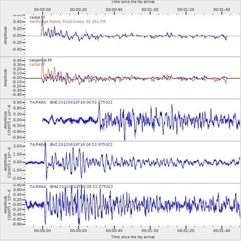
Signal To Noise
| Channel | StoN | STA | LTA |
| TA:R48A: :BHZ:20120619T16:06:52.67502Z | 9.7344475 | 9.040031E-7 | 9.28664E-8 |
| TA:R48A: :BHN:20120619T16:06:52.67502Z | 3.902385 | 3.0291554E-7 | 7.7623184E-8 |
| TA:R48A: :BHE:20120619T16:06:52.67502Z | 3.4951136 | 3.1165936E-7 | 8.917003E-8 |
| Arrivals |
| Ps | 3.4 SECOND |
| PpPs | 13 SECOND |
| PsPs/PpSs | 17 SECOND |


