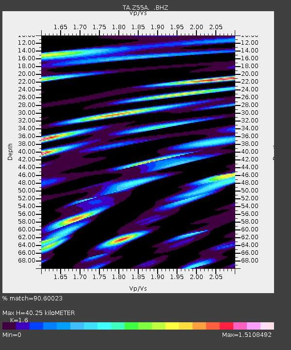
Z55A Blythe, GA, USA - Earthquake Result Viewer
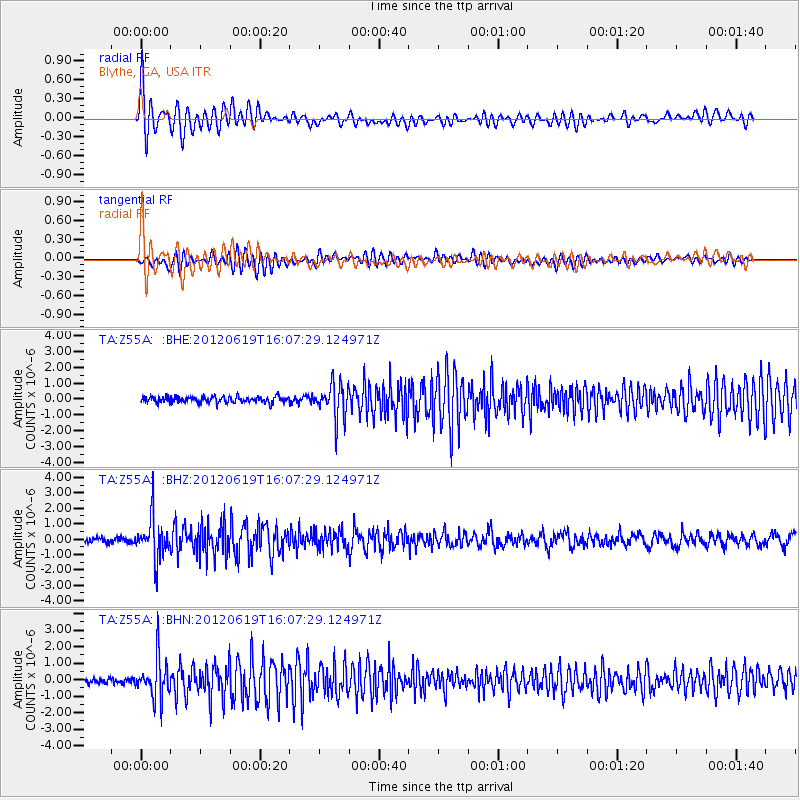
Earthquake location: Near Islands, Aleutian Islands
Earthquake latitude/longitude: 53.4/171.6
Earthquake time(UTC): 2012/06/19 (171) 15:56:32 GMT
Earthquake Depth: 14 km
Earthquake Magnitude: 6.2 MB, 5.7 MS, 6.0 MW, 6.1 MW
Earthquake Catalog/Contributor: WHDF/NEIC
Network: TA USArray Transportable Network (new EarthScope stations)
Station: Z55A Blythe, GA, USA
Lat/Lon: 33.22 N/82.14 W
Elevation: 100 m
Distance: 72.8 deg
Az: 57.404 deg
Baz: 322.949 deg
Ray Param: 0.05342131
Estimated Moho Depth: 40.25 km
Estimated Crust Vp/Vs: 1.60
Assumed Crust Vp: 6.565 km/s
Estimated Crust Vs: 4.103 km/s
Estimated Crust Poisson's Ratio: 0.18
Radial Match: 90.60023 %
Radial Bump: 400
Transverse Match: 83.429695 %
Transverse Bump: 400
SOD ConfigId: 460165
Insert Time: 2013-02-11 22:34:33.563 +0000
GWidth: 2.5
Max Bumps: 400
Tol: 0.001

Signal To Noise

ChannelStoNSTALTA
TA:Z55A: :BHZ:20120619T16:07:29.124971Z8.8597441.3265529E-61.4972814E-7
TA:Z55A: :BHN:20120619T16:07:29.124971Z6.8379471.2269202E-61.7942816E-7
TA:Z55A: :BHE:20120619T16:07:29.124971Z5.67756841.0746577E-61.8928132E-7
Arrivals
Ps3.8 SECOND
PpPs15 SECOND
PsPs/PpSs19 SECOND