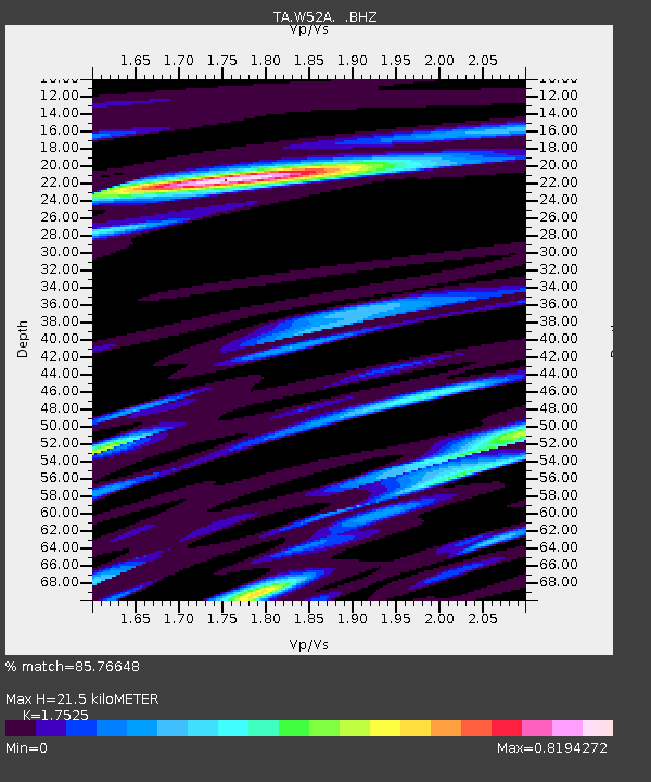
W52A Murphy, NC, USA - Earthquake Result Viewer
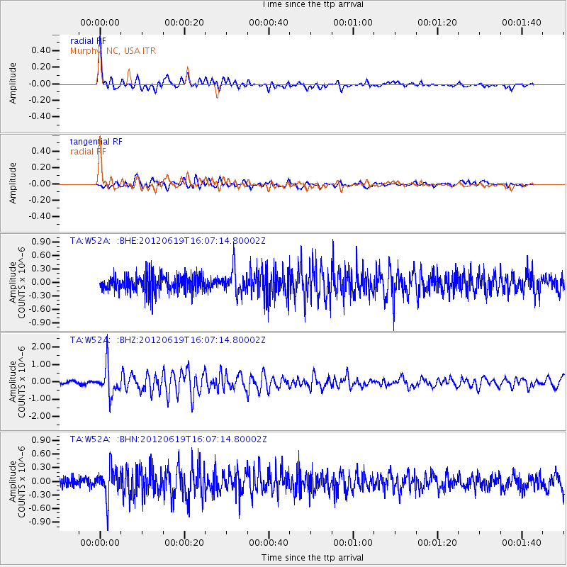
Earthquake location: Near Islands, Aleutian Islands
Earthquake latitude/longitude: 53.4/171.6
Earthquake time(UTC): 2012/06/19 (171) 15:56:32 GMT
Earthquake Depth: 14 km
Earthquake Magnitude: 6.2 MB, 5.7 MS, 6.0 MW, 6.1 MW
Earthquake Catalog/Contributor: WHDF/NEIC
Network: TA USArray Transportable Network (new EarthScope stations)
Station: W52A Murphy, NC, USA
Lat/Lon: 35.09 N/83.93 W
Elevation: 519 m
Distance: 70.4 deg
Az: 57.447 deg
Baz: 321.96 deg
Ray Param: 0.054997314
Estimated Moho Depth: 21.5 km
Estimated Crust Vp/Vs: 1.75
Assumed Crust Vp: 6.35 km/s
Estimated Crust Vs: 3.623 km/s
Estimated Crust Poisson's Ratio: 0.26
Radial Match: 85.76648 %
Radial Bump: 400
Transverse Match: 78.484566 %
Transverse Bump: 400
SOD ConfigId: 460165
Insert Time: 2013-02-11 22:35:20.748 +0000
GWidth: 2.5
Max Bumps: 400
Tol: 0.001

Signal To Noise

ChannelStoNSTALTA
TA:W52A: :BHZ:20120619T16:07:14.80002Z11.4841478.340989E-77.2630456E-8
TA:W52A: :BHN:20120619T16:07:14.80002Z2.78435523.3820308E-71.214655E-7
TA:W52A: :BHE:20120619T16:07:14.80002Z1.46074752.733888E-71.8715677E-7
Arrivals
Ps2.6 SECOND
PpPs9.0 SECOND
PsPs/PpSs12 SECOND