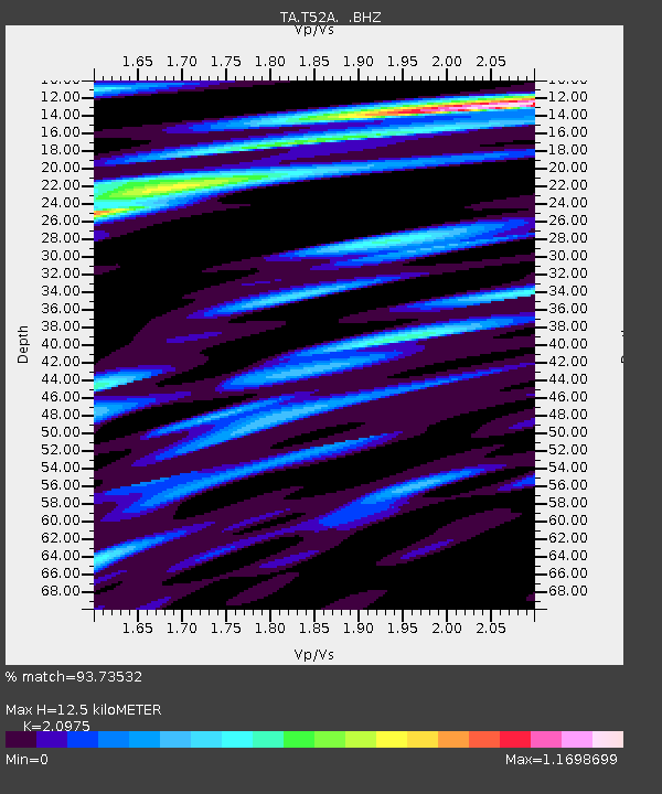
T52A Hallie, KY, USA - Earthquake Result Viewer
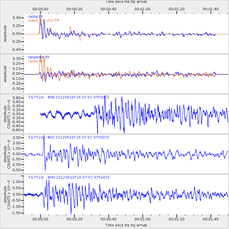
Earthquake location: Near Islands, Aleutian Islands
Earthquake latitude/longitude: 53.4/171.6
Earthquake time(UTC): 2012/06/19 (171) 15:56:32 GMT
Earthquake Depth: 14 km
Earthquake Magnitude: 6.2 MB, 5.7 MS, 6.0 MW, 6.1 MW
Earthquake Catalog/Contributor: WHDF/NEIC
Network: TA USArray Transportable Network (new EarthScope stations)
Station: T52A Hallie, KY, USA
Lat/Lon: 37.11 N/82.99 W
Elevation: 436 m
Distance: 69.3 deg
Az: 55.486 deg
Baz: 321.838 deg
Ray Param: 0.055735108
Estimated Moho Depth: 12.5 km
Estimated Crust Vp/Vs: 2.10
Assumed Crust Vp: 6.476 km/s
Estimated Crust Vs: 3.087 km/s
Estimated Crust Poisson's Ratio: 0.35
Radial Match: 93.73532 %
Radial Bump: 400
Transverse Match: 73.08896 %
Transverse Bump: 400
SOD ConfigId: 460165
Insert Time: 2013-02-11 22:36:21.456 +0000
GWidth: 2.5
Max Bumps: 400
Tol: 0.001

Signal To Noise

ChannelStoNSTALTA
TA:T52A: :BHZ:20120619T16:07:07.975007Z12.4678531.2375817E-69.926182E-8
TA:T52A: :BHN:20120619T16:07:07.975007Z7.14365.058768E-77.081539E-8
TA:T52A: :BHE:20120619T16:07:07.975007Z2.89965082.799739E-79.655435E-8
Arrivals
Ps2.2 SECOND
PpPs5.8 SECOND
PsPs/PpSs8.0 SECOND