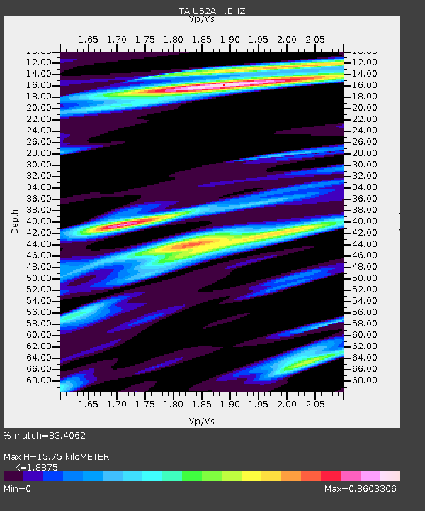
U52A Thorn Hill, TN, USA - Earthquake Result Viewer
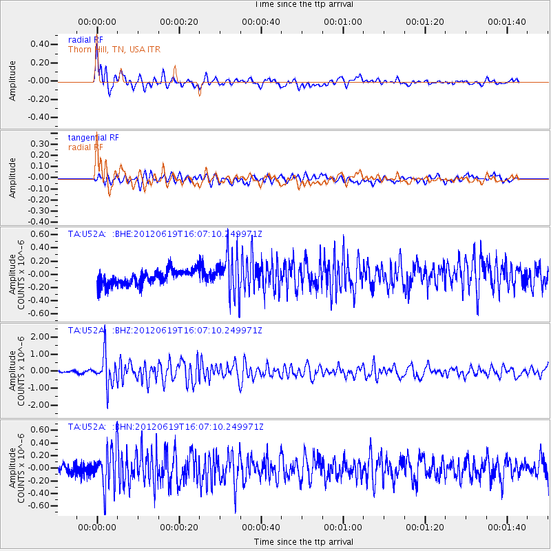
Earthquake location: Near Islands, Aleutian Islands
Earthquake latitude/longitude: 53.4/171.6
Earthquake time(UTC): 2012/06/19 (171) 15:56:32 GMT
Earthquake Depth: 14 km
Earthquake Magnitude: 6.2 MB, 5.7 MS, 6.0 MW, 6.1 MW
Earthquake Catalog/Contributor: WHDF/NEIC
Network: TA USArray Transportable Network (new EarthScope stations)
Station: U52A Thorn Hill, TN, USA
Lat/Lon: 36.39 N/83.37 W
Elevation: 510 m
Distance: 69.7 deg
Az: 56.214 deg
Baz: 321.865 deg
Ray Param: 0.055488277
Estimated Moho Depth: 15.75 km
Estimated Crust Vp/Vs: 1.89
Assumed Crust Vp: 6.476 km/s
Estimated Crust Vs: 3.431 km/s
Estimated Crust Poisson's Ratio: 0.30
Radial Match: 83.4062 %
Radial Bump: 400
Transverse Match: 63.918785 %
Transverse Bump: 400
SOD ConfigId: 460165
Insert Time: 2013-02-11 22:37:18.399 +0000
GWidth: 2.5
Max Bumps: 400
Tol: 0.001

Signal To Noise

ChannelStoNSTALTA
TA:U52A: :BHZ:20120619T16:07:10.249971Z9.5779959.064838E-79.464234E-8
TA:U52A: :BHN:20120619T16:07:10.249971Z3.65226053.1016603E-78.49244E-8
TA:U52A: :BHE:20120619T16:07:10.249971Z3.00629733.2734945E-71.0888792E-7
Arrivals
Ps2.2 SECOND
PpPs6.8 SECOND
PsPs/PpSs9.0 SECOND