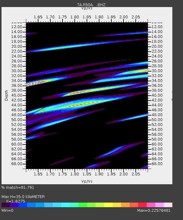
R50A Paris, KY, USA - Earthquake Result Viewer

Earthquake location: Near Islands, Aleutian Islands
Earthquake latitude/longitude: 53.4/171.6
Earthquake time(UTC): 2012/06/19 (171) 15:56:32 GMT
Earthquake Depth: 14 km
Earthquake Magnitude: 6.2 MB, 5.7 MS, 6.0 MW, 6.1 MW
Earthquake Catalog/Contributor: WHDF/NEIC
Network: TA USArray Transportable Network (new EarthScope stations)
Station: R50A Paris, KY, USA
Lat/Lon: 38.28 N/84.33 W
Elevation: 255 m
Distance: 67.7 deg
Az: 55.596 deg
Baz: 321.061 deg
Ray Param: 0.056768656
Estimated Moho Depth: 35.0 km
Estimated Crust Vp/Vs: 1.63
Assumed Crust Vp: 6.498 km/s
Estimated Crust Vs: 3.992 km/s
Estimated Crust Poisson's Ratio: 0.20
Radial Match: 91.791 %
Radial Bump: 400
Transverse Match: 57.968754 %
Transverse Bump: 400
SOD ConfigId: 460165
Insert Time: 2013-02-11 22:38:12.214 +0000
GWidth: 2.5
Max Bumps: 400
Tol: 0.001

Signal To Noise

ChannelStoNSTALTA
TA:R50A: :BHZ:20120619T16:06:58.124971Z16.0492088.6858813E-75.412031E-8
TA:R50A: :BHN:20120619T16:06:58.124971Z4.59640743.0099105E-76.548398E-8
TA:R50A: :BHE:20120619T16:06:58.124971Z3.6516932.6176485E-77.168315E-8
Arrivals
Ps3.5 SECOND
PpPs14 SECOND
PsPs/PpSs17 SECOND