You are here: Home > Network List > G - GEOSCOPE Stations List
> Station SPB Sao Paulo, Brazil > Earthquake Result Viewer
SPB Sao Paulo, Brazil - Earthquake Result Viewer
| Earthquake location: |
Gulf Of California |
| Earthquake latitude/longitude: |
23.8/-108.8 |
| Earthquake time(UTC): |
2009/01/05 (005) 10:59:30 GMT |
| Earthquake Depth: |
10 km |
| Earthquake Magnitude: |
5.7 MB, 5.2 MS, 5.5 MW, 5.5 MW |
| Earthquake Catalog/Contributor: |
WHDF/NEIC |
|
| Network: |
G GEOSCOPE |
| Station: |
SPB Sao Paulo, Brazil |
| Lat/Lon: |
23.59 S/47.43 W |
| Elevation: |
85 m |
|
| Distance: |
75.9 deg |
| Az: |
123.917 deg |
| Baz: |
304.056 deg |
| Ray Param: |
0.051349774 |
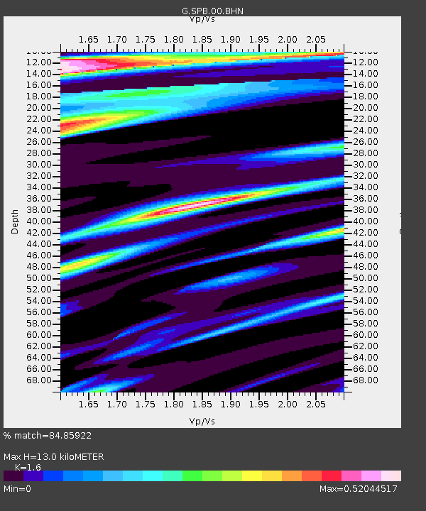
| Estimated Moho Depth: |
13.0 km |
| Estimated Crust Vp/Vs: |
1.60 |
| Assumed Crust Vp: |
6.419 km/s |
| Estimated Crust Vs: |
4.012 km/s |
| Estimated Crust Poisson's Ratio: |
0.18 |
|
| Radial Match: |
84.85922 % |
| Radial Bump: |
400 |
| Transverse Match: |
36.106094 % |
| Transverse Bump: |
400 |
| SOD ConfigId: |
2834 |
| Insert Time: |
2010-02-27 00:02:55.613 +0000 |
| GWidth: |
2.5 |
| Max Bumps: |
400 |
| Tol: |
0.001 |
|
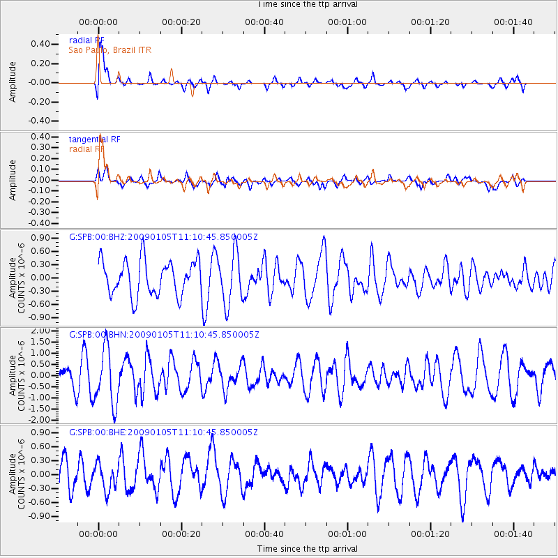
Signal To Noise
| Channel | StoN | STA | LTA |
| G:SPB:00:BHN:20090105T11:10:45.850005Z | 1.6453909 | 1.2499129E-6 | 7.59645E-7 |
| G:SPB:00:BHE:20090105T11:10:45.850005Z | 0.7998574 | 2.9118704E-7 | 3.6404867E-7 |
| G:SPB:00:BHZ:20090105T11:10:45.850005Z | 1.4963503 | 5.8481623E-7 | 3.9082843E-7 |
| Arrivals |
| Ps | 1.3 SECOND |
| PpPs | 5.1 SECOND |
| PsPs/PpSs | 6.3 SECOND |


