You are here: Home > Network List > TA - USArray Transportable Network (new EarthScope stations) Stations List
> Station M04C Macdoel, CA, USA > Earthquake Result Viewer
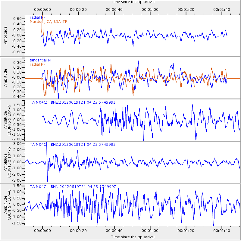
M04C Macdoel, CA, USA - Earthquake Result Viewer
*The percent match for this event was below the threshold and hence no stack was calculated.
| Earthquake location: |
Near Islands, Aleutian Islands |
| Earthquake latitude/longitude: |
53.4/171.7 |
| Earthquake time(UTC): |
2012/06/19 (171) 20:56:41 GMT |
| Earthquake Depth: |
12 km |
| Earthquake Magnitude: |
5.9 MB, 5.2 MS, 5.6 MW, 5.7 MW |
| Earthquake Catalog/Contributor: |
WHDF/NEIC |
|
| Network: |
TA USArray Transportable Network (new EarthScope stations) |
| Station: |
M04C Macdoel, CA, USA |
| Lat/Lon: |
41.78 N/121.84 W |
| Elevation: |
1391 m |
|
| Distance: |
44.7 deg |
| Az: |
76.954 deg |
| Baz: |
308.659 deg |
| Ray Param: |
$rayparam |
*The percent match for this event was below the threshold and hence was not used in the summary stack. |
|
| Radial Match: |
50.943645 % |
| Radial Bump: |
400 |
| Transverse Match: |
53.670685 % |
| Transverse Bump: |
400 |
| SOD ConfigId: |
460165 |
| Insert Time: |
2013-02-11 22:58:11.850 +0000 |
| GWidth: |
2.5 |
| Max Bumps: |
400 |
| Tol: |
0.001 |
|
Signal To Noise
| Channel | StoN | STA | LTA |
| TA:M04C: :BHZ:20120619T21:04:23.574999Z | 5.7891564 | 1.1015733E-6 | 1.9028217E-7 |
| TA:M04C: :BHN:20120619T21:04:23.574999Z | 0.9286002 | 3.6652017E-7 | 3.947018E-7 |
| TA:M04C: :BHE:20120619T21:04:23.574999Z | 1.5016803 | 6.528635E-7 | 4.3475532E-7 |
| Arrivals |
| Ps | |
| PpPs | |
| PsPs/PpSs | |


