You are here: Home > Network List > TA - USArray Transportable Network (new EarthScope stations) Stations List
> Station D31A Mcclaflin, Tower City, ND, USA > Earthquake Result Viewer
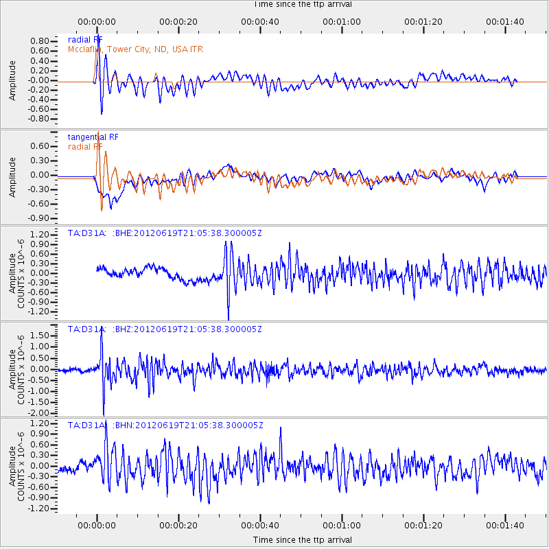
D31A Mcclaflin, Tower City, ND, USA - Earthquake Result Viewer
*The percent match for this event was below the threshold and hence no stack was calculated.
| Earthquake location: |
Near Islands, Aleutian Islands |
| Earthquake latitude/longitude: |
53.4/171.7 |
| Earthquake time(UTC): |
2012/06/19 (171) 20:56:41 GMT |
| Earthquake Depth: |
12 km |
| Earthquake Magnitude: |
5.9 MB, 5.2 MS, 5.6 MW, 5.7 MW |
| Earthquake Catalog/Contributor: |
WHDF/NEIC |
|
| Network: |
TA USArray Transportable Network (new EarthScope stations) |
| Station: |
D31A Mcclaflin, Tower City, ND, USA |
| Lat/Lon: |
47.05 N/97.72 W |
| Elevation: |
359 m |
|
| Distance: |
54.6 deg |
| Az: |
57.068 deg |
| Baz: |
312.626 deg |
| Ray Param: |
$rayparam |
*The percent match for this event was below the threshold and hence was not used in the summary stack. |
|
| Radial Match: |
79.13757 % |
| Radial Bump: |
400 |
| Transverse Match: |
70.944916 % |
| Transverse Bump: |
400 |
| SOD ConfigId: |
460165 |
| Insert Time: |
2013-02-11 23:02:02.967 +0000 |
| GWidth: |
2.5 |
| Max Bumps: |
400 |
| Tol: |
0.001 |
|
Signal To Noise
| Channel | StoN | STA | LTA |
| TA:D31A: :BHZ:20120619T21:05:38.300005Z | 11.293467 | 7.099014E-7 | 6.2859485E-8 |
| TA:D31A: :BHN:20120619T21:05:38.300005Z | 4.3305616 | 5.194442E-7 | 1.1994847E-7 |
| TA:D31A: :BHE:20120619T21:05:38.300005Z | 3.415925 | 5.6773365E-7 | 1.6620203E-7 |
| Arrivals |
| Ps | |
| PpPs | |
| PsPs/PpSs | |


