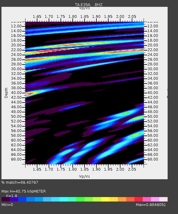
E35A Pequot Lakes, MN, USA - Earthquake Result Viewer
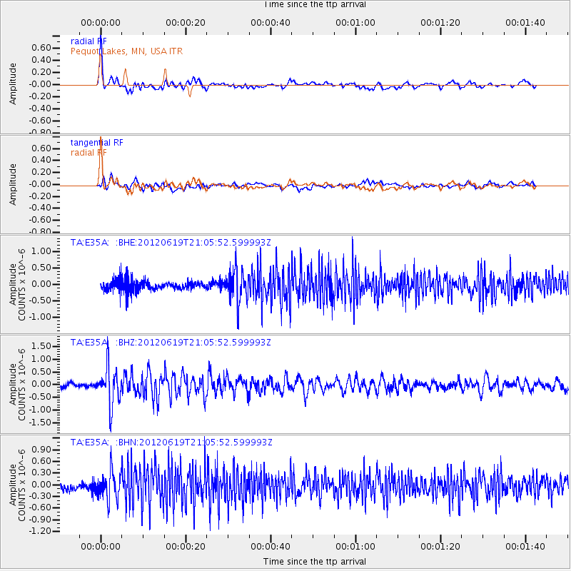
Earthquake location: Near Islands, Aleutian Islands
Earthquake latitude/longitude: 53.4/171.7
Earthquake time(UTC): 2012/06/19 (171) 20:56:41 GMT
Earthquake Depth: 12 km
Earthquake Magnitude: 5.9 MB, 5.2 MS, 5.6 MW, 5.7 MW
Earthquake Catalog/Contributor: WHDF/NEIC
Network: TA USArray Transportable Network (new EarthScope stations)
Station: E35A Pequot Lakes, MN, USA
Lat/Lon: 46.56 N/94.40 W
Elevation: 409 m
Distance: 56.6 deg
Az: 55.6 deg
Baz: 314.207 deg
Ray Param: 0.06406318
Estimated Moho Depth: 40.75 km
Estimated Crust Vp/Vs: 1.60
Assumed Crust Vp: 6.419 km/s
Estimated Crust Vs: 4.012 km/s
Estimated Crust Poisson's Ratio: 0.18
Radial Match: 86.40767 %
Radial Bump: 400
Transverse Match: 71.66896 %
Transverse Bump: 400
SOD ConfigId: 460165
Insert Time: 2013-02-11 23:02:41.206 +0000
GWidth: 2.5
Max Bumps: 400
Tol: 0.001

Signal To Noise

ChannelStoNSTALTA
TA:E35A: :BHZ:20120619T21:05:52.599993Z7.4529157.577764E-71.0167517E-7
TA:E35A: :BHN:20120619T21:05:52.599993Z3.40840653.5746552E-71.048776E-7
TA:E35A: :BHE:20120619T21:05:52.599993Z3.12754034.8737996E-71.558349E-7
Arrivals
Ps4.0 SECOND
PpPs16 SECOND
PsPs/PpSs20 SECOND