You are here: Home > Network List > G - GEOSCOPE Stations List
> Station SPB Sao Paulo, Brazil > Earthquake Result Viewer
SPB Sao Paulo, Brazil - Earthquake Result Viewer
| Earthquake location: |
Lake Tanganyika Region |
| Earthquake latitude/longitude: |
-8.0/30.7 |
| Earthquake time(UTC): |
2000/10/02 (276) 02:25:31 GMT |
| Earthquake Depth: |
34 km |
| Earthquake Magnitude: |
6.1 MB, 6.7 MS, 6.5 MW, 6.2 ME |
| Earthquake Catalog/Contributor: |
WHDF/NEIC |
|
| Network: |
G GEOSCOPE |
| Station: |
SPB Sao Paulo, Brazil |
| Lat/Lon: |
23.59 S/47.43 W |
| Elevation: |
85 m |
|
| Distance: |
76.0 deg |
| Az: |
247.703 deg |
| Baz: |
92.686 deg |
| Ray Param: |
0.05122688 |
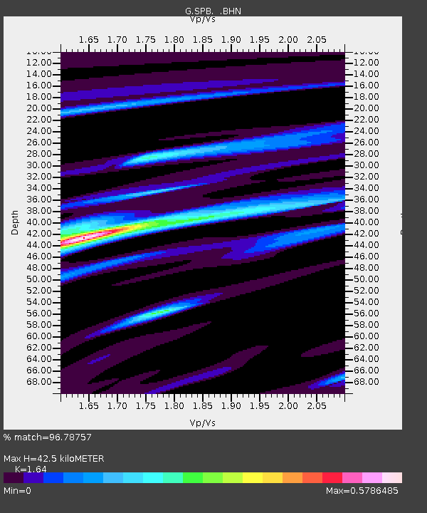
| Estimated Moho Depth: |
42.5 km |
| Estimated Crust Vp/Vs: |
1.64 |
| Assumed Crust Vp: |
6.419 km/s |
| Estimated Crust Vs: |
3.914 km/s |
| Estimated Crust Poisson's Ratio: |
0.20 |
|
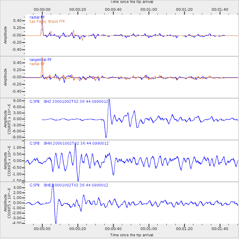
| Radial Match: |
96.78757 % |
| Radial Bump: |
256 |
| Transverse Match: |
91.278564 % |
| Transverse Bump: |
400 |
| SOD ConfigId: |
3744 |
| Insert Time: |
2010-02-27 00:03:42.001 +0000 |
| GWidth: |
2.5 |
| Max Bumps: |
400 |
| Tol: |
0.001 |
|
Signal To Noise
| Channel | StoN | STA | LTA |
| G:SPB: :BHN:20001002T02:36:44.099001Z | 1.6695538 | 1.5650863E-7 | 9.37428E-8 |
| G:SPB: :BHE:20001002T02:36:44.099001Z | 1.821161 | 1.5143065E-7 | 8.315062E-8 |
| G:SPB: :BHZ:20001002T02:36:44.099001Z | 0.90720695 | 2.0678543E-7 | 2.2793633E-7 |
| Arrivals |
| Ps | 4.4 SECOND |
| PpPs | 17 SECOND |
| PsPs/PpSs | 21 SECOND |


