You are here: Home > Network List > TA - USArray Transportable Network (new EarthScope stations) Stations List
> Station Y44A Strider, Charleston, MS, USA > Earthquake Result Viewer
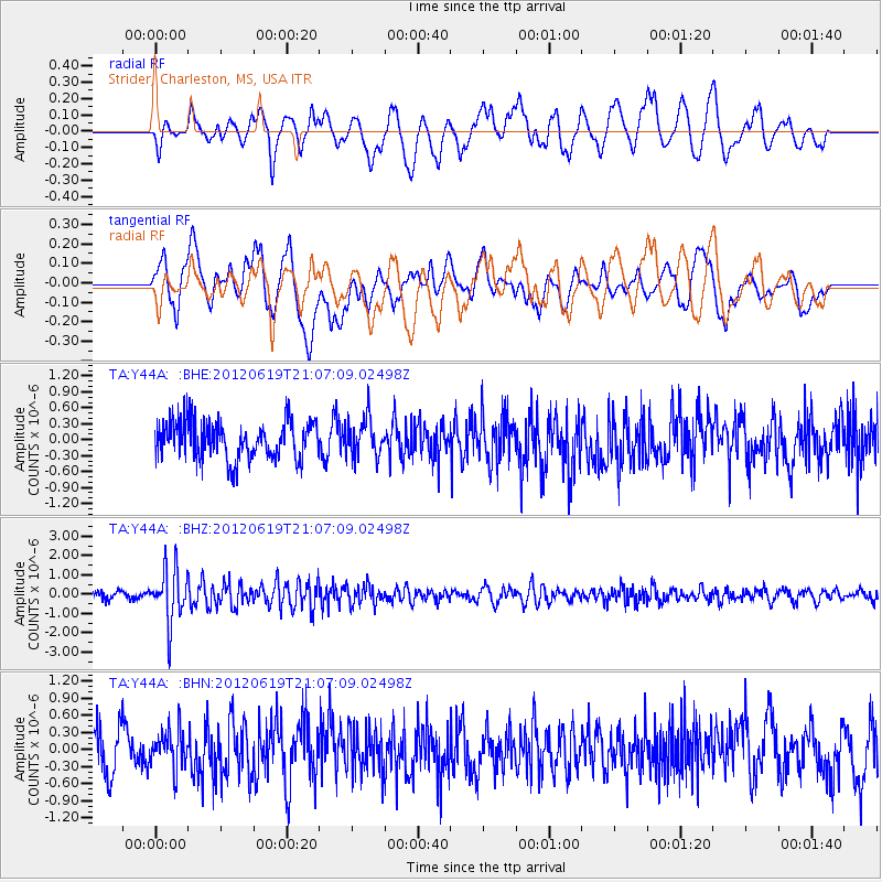
Y44A Strider, Charleston, MS, USA - Earthquake Result Viewer
*The percent match for this event was below the threshold and hence no stack was calculated.
| Earthquake location: |
Near Islands, Aleutian Islands |
| Earthquake latitude/longitude: |
53.4/171.7 |
| Earthquake time(UTC): |
2012/06/19 (171) 20:56:41 GMT |
| Earthquake Depth: |
12 km |
| Earthquake Magnitude: |
5.9 MB, 5.2 MS, 5.6 MW, 5.7 MW |
| Earthquake Catalog/Contributor: |
WHDF/NEIC |
|
| Network: |
TA USArray Transportable Network (new EarthScope stations) |
| Station: |
Y44A Strider, Charleston, MS, USA |
| Lat/Lon: |
33.96 N/90.21 W |
| Elevation: |
46 m |
|
| Distance: |
68.0 deg |
| Az: |
62.578 deg |
| Baz: |
320.19 deg |
| Ray Param: |
$rayparam |
*The percent match for this event was below the threshold and hence was not used in the summary stack. |
|
| Radial Match: |
58.131874 % |
| Radial Bump: |
400 |
| Transverse Match: |
50.69138 % |
| Transverse Bump: |
400 |
| SOD ConfigId: |
460165 |
| Insert Time: |
2013-02-11 23:12:48.698 +0000 |
| GWidth: |
2.5 |
| Max Bumps: |
400 |
| Tol: |
0.001 |
|
Signal To Noise
| Channel | StoN | STA | LTA |
| TA:Y44A: :BHZ:20120619T21:07:09.02498Z | 7.8578796 | 1.3902942E-6 | 1.7692994E-7 |
| TA:Y44A: :BHN:20120619T21:07:09.02498Z | 1.0327709 | 3.399505E-7 | 3.2916353E-7 |
| TA:Y44A: :BHE:20120619T21:07:09.02498Z | 1.0155574 | 3.5988927E-7 | 3.5437608E-7 |
| Arrivals |
| Ps | |
| PpPs | |
| PsPs/PpSs | |


